The National Geologic Map Database is migrating to a new infrastructure. We apologize for any service disruptions during this process.
|
|---|


- Usage in publication:
-
- Anona chalk
- Modifications:
-
- Original reference
- Dominant lithology:
-
- Chalk
- AAPG geologic province:
-
- Ouachita folded belt
Summary:
Pg. 308. Anona chalk. Pure white chalk, called White Cliffs chalk in Arkansas and Anona chalk in Texas. Underlies marls called Brownstown marls in Arkansas and Kickapoo marls in Texas. Overlies Taylor marls. [Age is Late Cretaceous.]
[Named from outcrops about 2 mi northwest of Annona, Red River Co., northeastern TX.]
[According to GNU records (USGS DDS-6; Denver GNULEX), misspelling of Annona corrected by A.C. Veatch, 1905, Louisiana Geol. Survey Bull., no. 1, p. 82-91.]
Source: US geologic names lexicon (USGS Bull. 896, p. 55-56).

- Usage in publication:
-
- Annona chalk
- Modifications:
-
- Overview
Summary:
Annona chalk. According to 1925 and 1926 work of L.W. Stephenson and C.H. Dane (USGS Press Bull. 8823, Sept. 10, 1926; AAPG Bull., v. 11, p. 9; 1927; Arkansas Geol. Survey Bull., no. 1, p. 79, 1929) the Annona chalk in Arkansas underlies Marlbrook marl restricted (mistaken for the older Brownstown marl in early reports) and overlies Ozan formation (upper and unconformable part of Taylor marl). In northeastern Texas, the Annona rests unconformably on Brownstown marl restricted (=lower part of Brownstown marl of earlier usage) and unconformably underlies marl that is believed to be upper part of Taylor marl. According to L.W. Stephenson, 1937 (USGS Prof. Paper 186-G, p. 135), Ozan formation part of Annona limestone = lower part of Taylor marl.
Source: US geologic names lexicon (USGS Bull. 896, p. 55-56).
- Usage in publication:
-
- Annona chalk*
- Modifications:
-
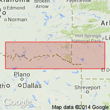
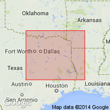
- Areal extent
- AAPG geologic province:
-
- Ouachita folded belt
Summary:
Pg. 133-146. Annona chalk, which in eastern Red River County, northeastern Texas, is estimated to be 300 or 400 feet thick, is time equivalent of combined lower part of Taylor marl, Wolf City sand member, and Pecan Gap member of Lamar, Delta, and Fannin Counties. Phosphatic bed that forms base of Annona chalk north of White Rock, in Red River County, has been traced westward and found to be continuous with phosphatic bed at base of Taylor marl just above Gober tongue of Austin chalk in Lamar County. In southwestern Arkansas, Annona chalk and underlying Ozan formation are together the approximate time equivalent of Annona chalk in Red River County, Texas. [Age is Late Cretaceous.]
Source: US geologic names lexicon (USGS Bull. 1200, p. 105).
- Usage in publication:
-
- Annona chalk
- Modifications:
-
- Revised
- AAPG geologic province:
-
- Ouachita folded belt
Summary:
Pg. 43-45. Annona chalk included in Taylor group. Pecan Gap chalk has been considered to be tongue of Annona chalk, with lower marl [east of Taylor group] and Wolfe City sand being lateral equivalents of lower part of Annona chalk (interpretation accepted here). Foraminifera described. [Age is Late Cretaceous.]
Source: US geologic names lexicon (USGS Bull. 1200, p. 105).
- Usage in publication:
-
- Annona chalk
- Modifications:
-
- Revised
- AAPG geologic province:
-
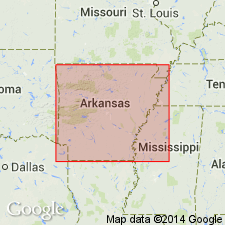
- Desha basin
Summary:
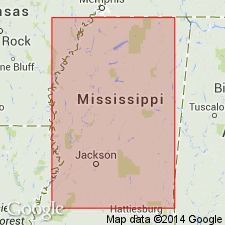
Pg. 29-40. Annona chalk. Name Annona first projected into Mississippi into a part of Selma chalk by Shreveport Geological Society. In stratigraphic cross sections, projection was from Desha basin on north side of Monroe-Sharkey uplift and also within salt basin province south of Monroe-Sharkey uplift. Nomenclature and usage are set out in Gulf Cretaceous correlation chart (Shreveport Geol. Soc., 1945, v. 2, p. 480-481). In present study, it was assumed that stratigraphic studies and correlations of Annona section by Shreveport stratigraphers were essentially correct. It was upon this premise, that name Annona chalk was adopted to apply to a portion of lower part of Demopolis chalk. A 2-foot bed in upper part of Annona chalk as used herein has been traced over an area of all or part of more than 40 counties in Mississippi. This bed is herein named Coonewah, for outcrops in Coonewah Creek valley. Most data subsurface. [Age is Late Cretaceous.]
[Coonewah Bed now (ca. 1960) included in Demopolis Formation; Annona restricted from MS.]
Source: US geologic names lexicon (USGS Bull. 1200, p. 105).

- Usage in publication:
-
- Annona Chalk
- Modifications:
-
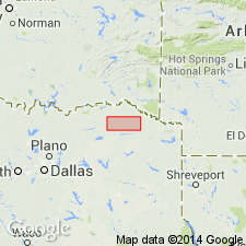
- Mapped 1:250k
- Dominant lithology:
-
- Chalk
- AAPG geologic province:
-
- Arkla basin
- Ouachita folded belt
Summary:
Annona Chalk. In Texas, chalk, in part argillaceous and sandy, thick-bedded to massive, hard, bluish-white; weathers white; scattered marine megafossils; thickness 450+/- feet, thins eastward. In Arkansas, upper 60 feet, massive, beds 1 to 10 feet, creamy white; lower 25 feet, silty, sandy, massive, dull bluish-white; weathers light brownish-gray to white; scattered marine megafossils; thickness 85 to 100 feet. [Upper part correlative with Pecan Gap Chalk mapped west of Clarksville, Texas. Overlies and intertongues with Ozan Formation; underlies Marlbrook Marl.] Age is Late Cretaceous.
[Mapped around and east of Clarksville, in Red River Co., northeastern TX, and in a few places in Little River Co., southwestern AR.]
Source: Publication.
- Usage in publication:
-
- Annona Chalk*
- Modifications:
-
- Paleomagnetics
- AAPG geologic province:
-
- Ouachita folded belt
Summary:
Annona Chalk. Paleomagnetic (a.f. demagnetized) data indicates the Upper Cretaceous Annona Chalk, in southwest Arkansas, possesses a weak remanent magnetization of normal magnetic polarity. The normal polarity is assumed to be primary magnetization, and is interpreted to represent deposition during the Gubbio (Italy) normal polarity zone B+ (Campanian to early Maestrichtian).
Source: GNU records (USGS DDS-6; Denver GNULEX).
- Usage in publication:
-
- Annona Chalk
- Annona Formation
- AAPG geologic province:
-
- Arkla basin
- Ouachita folded belt
Summary:
Pg. 2 (corr. chart), 30. Annona Chalk; Annona Formation. Hard, thick-bedded to massive, slightly fossiliferous chalk. Weathers white, but is blue-gray when freshly exposed. Thickness 0 to 100 feet. Conformably overlies Ozan Formation. Is older than Marlbrook Marl. Commercially mined for cement. Age is Late Cretaceous (Gulfian Provincial Epoch).
Recognized in parts of Hempstead, Howard, and Little River Cos., AR.
Source: Publication.
For more information, please contact Nancy Stamm, Geologic Names Committee Secretary.
Asterisk (*) indicates published by U.S. Geological Survey authors.
"No current usage" (†) implies that a name has been abandoned or has fallen into disuse. Former usage and, if known, replacement name given in parentheses ( ).
Slash (/) indicates name conflicts with nomenclatural guidelines (CSN, 1933; ACSN, 1961, 1970; NACSN, 1983, 2005, 2021). May be explained within brackets ([ ]).