

- Usage in publication:
-
- Amole arkose
- Modifications:
-
- Original reference
- Dominant lithology:
-
- Arkose
- Shale
- AAPG geologic province:
-
- Basin-and-Range province
Summary:
Pg. 710 (fig. 2), 713, 716-720, pl. 1. Amole arkose. Series of gray to pink coarse-grained arkose, interbedded with shales and a few limestone beds; characterized by rapid and repeated changes in rock type; interbedded shales are usually silvery gray. Few of the limestone units are more than 2 feet thick, and most of them are very thin-bedded and range in color from blue-gray to black. Unconformably underlies Cat Mountain rhyolite (new); conformably overlies Recreation redbeds (new) into which it grades through a zone about 75 feet thick. Thickness of formation about 2,275 feet [measured near the Ranger Station]. Similarity in some limestone beds suggests repetition in the section, but this could not be proved. Top of Cretaceous is apparently not exposed in range but is cut off either by erosion, as in measured section, or by overthrust sheet. [Age is Early Cretaceous and (or) Late Cretaceous.]
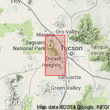
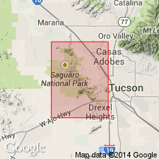
Area: Tucson Mountains, southeastern AZ. Amole arkose crops out chiefly on western side of southern part of range and extends north to Amole Peak [center sec. 30, T. 13 S., R. 12 E., Lat. 32 deg. 16 min. 20 sec. N., Long. 111 deg. 09 min. 18 sec. W., Avra 7.5-min quadrangle, Pima Co., Saguaro National Park, southeastern AZ], where it is cut off by granitoid intrusives. Northeastern part of belt extends across and around eastern side of peak.
Source: US geologic names lexicon (USGS Bull. 1200, p. 82-83).

- Usage in publication:
-
- Amole Arkose*
- Modifications:
-
- Overview
- AAPG geologic province:
-
- Basin-and-Range province
Summary:
Of Brown (1939). Is oldest Cretaceous formation in Tucson Mountains (Pima Co, AZ) in Basin-and-Range province. Overlies Recreation Redbeds (Triassic) of Brown (1939). Underlies Tucson Mountains Chaos (Campanian) of Kinnison (1959). Is 2,275 ft thick in one measured section. In type area is very similar in lithology to rocks of Bisbee Group of Early Cretaceous age in Empire and northern Santa Rita Mountains and is considered to be an approximate correlative. Suggests that pollen-bearing Upper Cretaceous beds reported by Kinnison (1959) in southern part of mountains are unconformable on underlying parts of Amole, are younger than any Amole in type area, and may be more closely allied to Upper Cretaceous sedimentary rocks elsewhere in the region. Age is shown to be Aptian and Albian (Early Cretaceous) on correlation chart (fig. 5).
Source: GNU records (USGS DDS-6; Denver GNULEX).
- Usage in publication:
-
- Amole Arkose*
- Modifications:
-
- Age modified
- AAPG geologic province:
-
- Basin-and-Range province
Summary:
Age modified to Cretaceous. Study area is Tucson Mountains, Pima Co, AZ, Basin-and-Range province. Unit commonly considered correlative with Lower Cretaceous Bisbee Group, but lithologic continuity with Upper Cretaceous sedimentary rocks that overlie 73-Ma tuff of Confidence Peak suggest that Amole could also be partly or entirely Upper Cretaceous, if so, absence of Bisbee Group in Tucson Mountains would be puzzling. Greater than 1000 m thick. Unconformably overlies Recreation Red Beds; underlies tuff of Confidence Peak (a crystal-rich gray welded rhyolitic tuff that erupted from Silver Bell caldera 30 km northwest of Tucson Mountains caldera).
Source: GNU records (USGS DDS-6; Denver GNULEX).
For more information, please contact Nancy Stamm, Geologic Names Committee Secretary.
Asterisk (*) indicates published by U.S. Geological Survey authors.
"No current usage" (†) implies that a name has been abandoned or has fallen into disuse. Former usage and, if known, replacement name given in parentheses ( ).
Slash (/) indicates name conflicts with nomenclatural guidelines (CSN, 1933; ACSN, 1961, 1970; NACSN, 1983, 2005, 2021). May be explained within brackets ([ ]).