

- Usage in publication:
-
- Allsboro sandstone
- Modifications:
-
- Original reference
- Dominant lithology:
-
- Sandstone
- AAPG geologic province:
-
- Black Warrior basin
Morse, W.C., 1928, Paleozoic rocks of Mississippi: Journal of Geology, v. 36, no. 1, p. 31-43.
Summary:
Pg. 31-43. Allsboro sandstone. Coarse-grained sandstone, in places decidedly contorted, thus differing from other sandstones in the region. At a few places contains a little asphaltic material. Thickness 8 feet.
Named from small village in AL, near MS line. Overlies Alsobrook formation and underlies Southward Pond formation. Is correlated with Bethel sandstone [not true Bethel, but Yankeetown chert; true Bethel sandstone underlies Renault formation, which which Morse correlates his Alsobrook formation.] [Age is Late Mississippian (Chester).]
Named from small village of Allsboro in northwestern AL, near MS line.
Source: US geologic names lexicon (USGS Bull. 896, p. 35-36).
- Usage in publication:
-
- Allsboro sandstone
- Modifications:
-
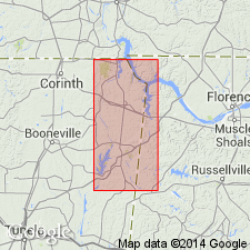
- Areal extent
- Dominant lithology:
-
- Shale
- AAPG geologic province:
-
- Black Warrior basin
Summary:
Thickness of Allsboro sandstone varies from 3 to 9 feet. In north end of Allsboro, Alabama, it consists of 5 feet of massive and contorted sandstone and bluish gray shale. [Age is Late Mississippian (Chester).]
Well exposed north and south of Allsboro, Colbert Co., northwestern AL, and Tishomingo Co., northeastern MS.
Source: US geologic names lexicon (USGS Bull. 896, p. 35-36).
- Usage in publication:
-
- Allsboro sandstone†
- Modifications:
-
- Abandoned
- AAPG geologic province:
-
- Black Warrior basin
Summary:
Allsboro sandstone of Morse (1928) included in Tanyard Branch member of Pride Mountain formation (both new). Tanyard Branch also includes underlying strata of Morse's Cripple Deer sandstone member of his Alsobrook formation. Alsobrook is restricted and reduced to member rank at the base of the Pride Mountain formation. [Age is Late Mississippian (Chester).]
Source: US geologic names lexicon (USGS Bull. 1200, p. 58); supplemental information from GNU records (USGS DDS-6; Reston GNULEX).
For more information, please contact Nancy Stamm, Geologic Names Committee Secretary.
Asterisk (*) indicates published by U.S. Geological Survey authors.
"No current usage" (†) implies that a name has been abandoned or has fallen into disuse. Former usage and, if known, replacement name given in parentheses ( ).
Slash (/) indicates name conflicts with nomenclatural guidelines (CSN, 1933; ACSN, 1961, 1970; NACSN, 1983, 2005, 2021). May be explained within brackets ([ ]).