The National Geologic Map Database is migrating to a new infrastructure. We apologize for any service disruptions during this process.
|
|---|


- Usage in publication:
-
- Aguja formation
- Modifications:
-
- Original reference
- Dominant lithology:
-
- Sandstone
- Shale
- Clay
- AAPG geologic province:
-
- Permian basin
Summary:
Pg. 239, 271, 505. Aguja formation. When in 1907 Dr. Udden described his "Rattlesnake" formation, the name had already been used for a formation in Oregon Pliocene. Accordingly the name Aguja is here substituted for Udden's name. Type locality is Sierra Aguja (Needle Peak), in the flat in front of Santa Helena fault scarp, 6 miles south of Terlingua, Brewster County, western Texas. The slopes and surrounding flats contain a practically complete section of the beds, overlain by Tornillo clay, and situated close to Udden's original type locality. [Distribution and fossils discussed.] Age is considered Late Cretaceous (Gulf). Upper part of formation is of Navarro age and lower part of Taylor age.
Consists of: varicolored, coarse-grained, fossiliferous sandstone, as much as 60 feet thick; lustrous to dull-black, nonmarine, carbonaceous, lignite-bearing shales containing extensive reptilian remains; and massive, shelly clays, similar to the Taylor clays but generally more sandy or silty.
Source: US geologic names lexicon (USGS Bull. 896, p. 18); supplemental information from GNU records (USGS DDS-6; Denver GNULEX).
- Usage in publication:
-
- Aguja formation
- Modifications:
-
- Areal extent
- AAPG geologic province:
-
- Permian basin
Summary:
Pg. 153, 170-173, pl. 1. Aguja formation. Described in Agua Fria quadrangle. Consists primarily of sandstone and shale. Sandstone yellowish-gray, gray, and brown, fine-grained; shales light to dark-gray or almost black and blackish red; lignite and lignitic shales. Thickness, partial section, 101 feet. Underlies Terlingua beds; contact gradational. Wherever Aguja is overlain by Tertiary rocks, contact is distinctly marked by an unconformity which is angular in some localites and apparently disconformable in others. Age is Late Cretaceous (Gulf).
Source: US geologic names lexicon (USGS Bull. 1200, p. 29).
- Usage in publication:
-
- Aguja Formation
- Modifications:
-
- Mapped 1:250k
- Dominant lithology:
-
- Clay
- Sandstone
- Lignite
- AAPG geologic province:
-
- Permian basin
Summary:
Aguja Formation. Upper part, sandstone, clay, a few lignite beds and freshwater limestones, up to 880 feet thick. Lower part, chiefly clay, 175 to 500+ feet thick, and sandstone, 5 to 35 feet thick. Overlies Pen Formation; underlies Javelina Formation. Fossiliferous. Age is Late Cretaceous.
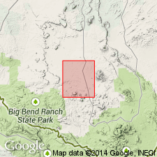
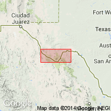
Mapped in Brewster County, Texas; notable exposures in Bofecillos area, Big Bend National Park, and Agua Fria quadrangle.
Source: Publication; supplemental information from GNU records (USGS DDS-6; Denver GNULEX).
For more information, please contact Nancy Stamm, Geologic Names Committee Secretary.
Asterisk (*) indicates published by U.S. Geological Survey authors.
"No current usage" (†) implies that a name has been abandoned or has fallen into disuse. Former usage and, if known, replacement name given in parentheses ( ).
Slash (/) indicates name conflicts with nomenclatural guidelines (CSN, 1933; ACSN, 1961, 1970; NACSN, 1983, 2005, 2021). May be explained within brackets ([ ]).