The National Geologic Map Database is migrating to a new infrastructure. We apologize for any service disruptions during this process.
|
|---|


- Usage in publication:
-
- Adaville formation*
- Modifications:
-
- Original reference
- Dominant lithology:
-
- Clay
- Sandstone
- Coal
- AAPG geologic province:
-
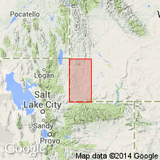
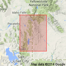
- Green River basin
Summary:
Adaville formation. Yellow, gray, and black carbonaceous clays, with irregularly bedded brown and yellow sandstones and numerous coal beds. South of Hodges Pass tunnel there is at base a prominent white sandstone (Lazeart sandstone member), 100 to 200 feet thick, immediately above which is Adaville-Lazeart coal, 20 to 84 feet thick, and associated with it beds containing plants and invertebrate remains older than Laramie; the overlying strata contain lower Laramie leaves. Thickness of formation 4,000+ feet. Unconformably underlies Evanston formation and overlies Hilliard formation. At Adaville mine, 2 mi south of Hodges Pass Tunnel, on Oregon Short Line, a bed of coal 84+ feet thick has been cut, and as a whole formation shows a like phenomenal amount of coal, and is, moreover, well exposed at this point, it has been named Adaville formation. Age is Late Cretaceous. [Fossils from lower part of formation identified by T.W. Stanton (invertebrates) and F.H. Knowlton (leaves), both of USGS; listed on p. 74-75. See also L.F. Ward's plant identifications, USGS Bull. 37, 1887, and USGS 6th Ann. Rpt., p. 541, 1885.]
Named from excellent exposures southwest of town of Moyer at Adaville Mine, 2 mi south of Hodges Pass tunnel on Oregon Short Line, in secs. 17, 18, 19, and 20, T. 21 N., R. 116 W., [Kemmerer 7.5-min quadrangle, Lincoln Co.], southwestern WY (see pl. 3, areal geol., scale 1:125,000).
Source: US geologic names lexicon (USGS Bull. 896, p. 13).
- Usage in publication:
-
- Adaville Formation*
- Modifications:
-
- Areal extent
- AAPG geologic province:
-
- Green River basin
Summary:
Becomes increasingly sandy north and northwestward in eastern part of thrust belt in Greater Green River basin until divisions of the Upper Cretaceous cannot be mapped. The newly named Blind Bull Formation is used for these Upper Cretaceous rocks and replaces use of terms such as "Adaville-Frontier" for the undivided sequence.
Source: GNU records (USGS DDS-6; Denver GNULEX).
- Usage in publication:
-
- Adaville Formation*
- Modifications:
-
- Areal extent
- AAPG geologic province:
-
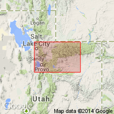
- Uinta uplift
Summary:
Mapped in the lower plate of the Absaroka thrust in Crandall Canyon-Frazier Hollow area, Summit Co, UT on Uinta uplift.
Source: GNU records (USGS DDS-6; Denver GNULEX).
For more information, please contact Nancy Stamm, Geologic Names Committee Secretary.
Asterisk (*) indicates published by U.S. Geological Survey authors.
"No current usage" (†) implies that a name has been abandoned or has fallen into disuse. Former usage and, if known, replacement name given in parentheses ( ).
Slash (/) indicates name conflicts with nomenclatural guidelines (CSN, 1933; ACSN, 1961, 1970; NACSN, 1983, 2005, 2021). May be explained within brackets ([ ]).