

- Usage in publication:
-
- Aberdeen sandstone
- Modifications:
-
- Original reference
- Dominant lithology:
-
- Sandstone
- AAPG geologic province:
-
- Illinois basin
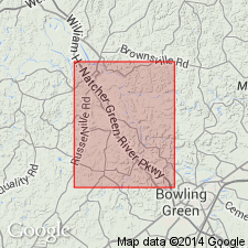
Summary:
Pg. 173-175. Aberdeen sandstone. Coarse, massive, cliff-forming sandstone, 40 feet thick, forming steep cliffs in region of Aberdeen, Butler County, [Kentucky]. Forms bluff on which Morgantown is situated. Base of sandstone is 75 feet above low water at Morgantown. Either rests on Aberdeen coal or is separated from it by 4 to 6 feet of shale. Well-marked erosional unconformity at base.
[Named from Aberdeen, Butler Co., KY, where it stands out in prominent cliffs along Green River. Typically exposed at Aberdeen Ferry.]
Source: US geologic names lexicon (USGS Bull. 896, p. 8).
- Usage in publication:
-
- Aberdeen sandstone
- Modifications:
-
- Areal extent
- AAPG geologic province:
-
- Illinois basin
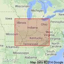
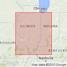
Summary:
Pg. 33. Aberdeen sandstone. Noted as occurring in Illinois and Indiana.
Source: US geologic names lexicon (USGS Bull. 1200, p. 8).

- Usage in publication:
-
- Aberdeen sandstone [unranked]
- Modifications:
-
- Revised
- AAPG geologic province:
-
- Illinois basin
Summary:
Chart no. 6 (column 26, western Kentucky, collated by H.R. Wanless and J.M. Weller). Aberdeen sandstone [unranked]. Shown on Pennsylvanian correlation chart as sandstone in Tradewater formation. Occurs below Mannington coal and above Ice House coal, both of Tradewater formation. Age is [Middle Pennsylvanian]; earliest Desmoinesian; earliest Westphalian C (base of Westphalian C = Aegir bed).
Source: Publication; US geologic names lexicon (USGS Bull. 1200, p. 8).
- Usage in publication:
-
- Aberdeen sandstone
- Modifications:
-
- Revised
- AAPG geologic province:
-
- Illinois basin
Summary:
Pg. 14 (fig. 2). Aberdeen sandstone. Shown on correlation chart as sandstone in Tradewater group. Below Rock Island coal and above Pope Creek coal.
Source: US geologic names lexicon (USGS Bull. 1200, p. 8).
For more information, please contact Nancy Stamm, Geologic Names Committee Secretary.
Asterisk (*) indicates published by U.S. Geological Survey authors.
"No current usage" (†) implies that a name has been abandoned or has fallen into disuse. Former usage and, if known, replacement name given in parentheses ( ).
Slash (/) indicates name conflicts with nomenclatural guidelines (CSN, 1933; ACSN, 1961, 1970; NACSN, 1983, 2005, 2021). May be explained within brackets ([ ]).