


- Usage in publication:
-
- Aarde shale member
- Modifications:
-
- Original reference
- Dominant lithology:
-
- Shale
- Coal
- AAPG geologic province:
-
- Cherokee basin
Summary:
Pg. 94, 96. Aarde shale member of Howard limestone of Wabaunsee group. [See under Bachelor Creek limestone. On p. 21 Aarde shale described as consisting of 3 feet of yellowish-gray, clayey shale containing Nodaway coal near base. On p. 20 it is given a thickness of 4.5 feet.] Overlies Bachelor Creek limestone member; underlies Church limestone member (both of Howard). Age is Late Pennsylvanian (Virgil).
Named from exposures at Aarde Farm, in sec. 4, T. 26 S., R. 11 E., Greenwood Co., KS; these exposures designated the type locality.
Source: US geologic names lexicon (USGS Bull. 896, p. 7); GNC KS-NE Pennsylvanian Corr. Chart, sheet 2, Oct. 1936; supplemental information from GNU records (USGS DDS-6; Denver GNULEX).

- Usage in publication:
-
- Aarde shale
- Modifications:
-
- Overview
Summary:
R.C. Moore, 1934 (personal communication April 20) stated that lower part of Howard limestone intertongues with upper part of Severy shale, which accounts for Aarde shale containing Nodaway coal. The underlying Bachelor Creek limestone also interfingers in Severy shale he stated.
Source: US geologic names lexicon (USGS Bull. 896, p. 7).

- Usage in publication:
-
- Aarde shale member
- Modifications:
-
- Overview
- AAPG geologic province:
-
- Cherokee basin
Summary:
Pg. 39, 205-207. Bachelor Creek limestone member is basal member of Howard limestone of Wabaunsee group, in southern Kansas, from Greenwood County southward. Where it is absent, as in northern Kansas, the Nodaway coal and other beds that are stratigraphically = Aarde shale member of Howard limestone are classed as belonging to top of Severy shale, because boundary between the 2 shales can not be drawn. In northern area Severy shale extends up to base of Church limestone. Age is Late Pennsylvanian (Virgil).
Named from Aarde Farm, in sec. 4, T. 26 S., R. 11 E., Greenwood Co., northeastern KS.
Source: US geologic names lexicon (USGS Bull. 896, p. 7); GNC KS-NE Pennsylvanian Corr. Chart, sheet 2, Oct. 1936; supplemental information from GNU records (USGS DDS-6; Denver GNULEX).

- Usage in publication:
-
- Aarde shale member
- Modifications:
-
- Overview
Summary:
Pg. 57 (fig. 22), 63, 70 (fig. 25). Aarde shale member of Howard limestone. Bluish- to yellowish-gray clayey and sandy shale containing a persistent coal bed (Nodaway), ranging from about 1 inch to 2 feet in thickness, and a persistent black fissile shale in many outcrops. Thickness ranges from about 2 to 15 feet. Underlies Church limestone member; overlies Bachelor Creek limestone member.
Source: US geologic names lexicon (USGS Bull. 1200, p. 7).
- Usage in publication:
-
- Aarde shale member*
- Modifications:
-
- Areal extent
- AAPG geologic province:
-
- Nemaha anticline
Summary:
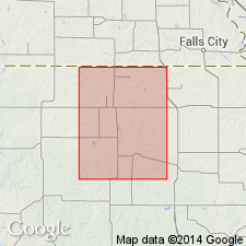
Pg. 193, 252-253, pl. 7. Aarde shale member of Howard limestone of Wabaunsee group. In Nemaha County, Kansas, Aarde shale member is the basal unit of Howard limestone of Wabaunsee group (Bachelor Creek limestone member is absent). Consists of silty, slightly calcareous dark gray to tan gray shale. Average thickness 4.5 feet. Base of Nodaway coal designated as base of Aarde; average thickness of the coal is 6 to 10 inches. Underlies Church limestone member of Howard. Microfossils present in beds overlying Nodaway coal. Age is Late Pennsylvanian.
Source: Publication; US geologic names lexicon (USGS Bull. 1200, p. 7); supplemental information from GNU records (USGS DDS-6; Denver GNULEX).
- Usage in publication:
-
- Aarde member
- Modifications:
-
- Revised
Summary:
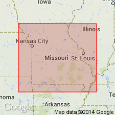
Aarde member of Howard formation of Sacfox subgroup [informal] of Wabaunsee group. Comprises (ascending) an underclay, the Nodaway bed, and a dark-gray shale with thin irregular beds of fossiliferous limestone. Thickness about 4 feet. Overlies Bachelor Creek member of Howard, a member that occurs only at 1 locality in Missouri. Underlies Church member of Howard. Age is Pennsylvanian.
["Subgroup" not recognized as a formal stratigraphic rank term (CSN, 1933; ACSN, 1961, 1970; NACSN, 1983, 2005, 2021). Considered informal and should not be capitalized.]
Source: Modified from GNU records (USGS DDS-6; Denver GNULEX).
- Usage in publication:
-
- Aarde Shale
- Modifications:
-
- Revised
- AAPG geologic province:
-
- Chautauqua platform
Summary:
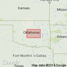
Aarde Shale of Ada Group. Raised to formation rank and assigned to Ada Group (rather than Wabaunsee Group) in Oklahoma City area, Oklahoma County, Oklahoma. Age is Late Pennsylvanian.
Source: Modified from GNU records (USGS DDS-6; Denver GNULEX).
- Usage in publication:
-
- Aarde Shale Member
- Modifications:
-
- Revised
- AAPG geologic province:
-
- Cherokee basin
Summary:
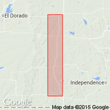
Aarde Shale Member (restricted) of Howard Limestone of Wabaunsee Group. The hard dense limestone and black fissile shale in the upper part of the Aarde are reallocated to newly named Wauneta Limestone and [Shanghai Creek] Shale Members (both of Howard), respectively. Aarde Shale Member (restricted) is 2 to 7 feet thick and consists of light-gray, brownish-weathering, fossiliferous shale that contains the Nodaway Coal Bed (citing N.J. McMillian, 1956, Kansas Geol. Survey Bull., no. 119, pt. 6, p. 191-249). Underlies Wauneta Limestone Member, where present. Overlies Bachelor Creek Limestone Member of Howard Limestone. Occurs in southern Kansas. Fossils include brachiopods, bryozoans, and crinoid fragments. Age is Late Pennsylvanian (Virgilian).
Source: Kansas lexicon (Kansas Geol. Survey Bull., no. 231, p. 1, 218, 258); supplemental information from GNU records (USGS DDS-6; Denver GNULEX).
For more information, please contact Nancy Stamm, Geologic Names Committee Secretary.
Asterisk (*) indicates published by U.S. Geological Survey authors.
"No current usage" (†) implies that a name has been abandoned or has fallen into disuse. Former usage and, if known, replacement name given in parentheses ( ).
Slash (/) indicates name conflicts with nomenclatural guidelines (CSN, 1933; ACSN, 1961, 1970; NACSN, 1983, 2005, 2021). May be explained within brackets ([ ]).