


- Usage in publication:
-
- Harebell formation*
- Modifications:
-
- Named
- Dominant lithology:
-
- Conglomerate
- Sandstone
- Shale
- AAPG geologic province:
-
- Yellowstone province
Summary:
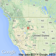
Named for Harebell Creek, a west-flowing stream in Snake River drainage along south margin of Yellowstone National Park, WY in Yellowstone province. Type locality extends from head of Snake River gorge south over Big Game ridge about 2 mi east of Mt. Hancock, and across Wolverine Creek to north base Pinyon Peak. Areal extent is Park and Teton (T48N, R113W) Cos, shown on map, an area of about 130 sq mi. Is 5,000 ft thick in type area. Is more than 4,000 ft thick along Buffalo Fork River, 3,500 ft thick on North Fork of Spread Creek, 869 ft thick on North Fork of Fish Creek, and 50 ft thick on Dry Cottonwood Creek. Quartzite pebble conglomerate present throughout sequence at type. At Blackrock Creek these conglomerate lenses are only in the upper part. To south conglomerate lenses are made of Paleozoic and Mesozoic rocks as well as quartzite. Includes olive-drab to gray sandstone, siltstone, and shale. Little volcanic material present. Unconformably overlies Bacon Ridge sandstone at type. Unconformably overlies Pinyon conglomerate. Is of very Late Cretaceous age, based on abundant plants and freshwater invertebrates (fossil list). Of Lance age.
Source: GNU records (USGS DDS-6; Denver GNULEX).
- Usage in publication:
-
- Harebell Formation*
- Modifications:
-
- Areal extent
- Overview
- Revised
- Dominant lithology:
-
- Sandstone
- Conglomerate
- AAPG geologic province:
-
- Yellowstone province
Summary:
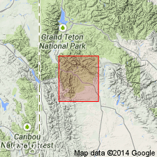
Crops out in an area of about 265 sq mi in Yellowstone province, northwest WY. A type locality (but no type section) designated by Love (1956). Type section designated in this report was measured in Snake River Canyon about 1 mi south of Barlow Peak, Yellowstone Park to head of north-facing cirque on divide between Wolverine and Fox Creeks, 3 1/2 mi south of Park boundary. Type section is a sequence of interbedded drab gray, dark gray, fine, medium, and coarse-grained, massive, thick-bedded, and cross-bedded sandstone; dark-brown conglomerate (of limestone and shale, and of quartzite pellets, pebbles, etc.); drab, black, dark gray and green, locally bentonitic claystone; brown siltstone; white hard siliceous tuff; and gray bentonite, 6,276+/-ft thick. Overlies Bacon Ridge Sandstone with angular unconformity at type. Underlies Pinyon Conglomerate at Pinyon Peak. Quartzite conglomerate 872 ft above base named Bobcat Member was formerly assigned to Pinyon Conglomerate. Harebell differs from Pinyon in that it is more indurated, olive-drab color, and has abundant volcanic debris. Amount of volcanic debris decreases from north to south across area. Has a maximum thickness of 11,000 ft. Is of Late Cretaceous age; has pollen, mollusk, dinosaur, ostracod, seed, and leaf fossils. Deposited by major river system draining the Targhee uplift in a humid, warm clime.
Source: GNU records (USGS DDS-6; Denver GNULEX).
- Usage in publication:
-
- Harebell Formation
- Modifications:
-
- Areal extent
- AAPG geologic province:
-
- Green River basin
Summary:
Overlies Mesaverde Sandstone; disconformably underlies Hoback Formation. Recognized on Park Creek (T41N, R110W), Park Co., WY (Yellowstone province) and at south end of Hoback canyon, northern Sublette Co., WY (Greater Green River basin). Consists of purple, gray, black shale, gray-tan and gray-purple lenticular sandstone 100-150 m thick in the Hoback basin (of the Greater Green River basin). Pollen samples gave a late Maastrichtian, Late Cretaceous age.
Source: GNU records (USGS DDS-6; Denver GNULEX).
For more information, please contact Nancy Stamm, Geologic Names Committee Secretary.
Asterisk (*) indicates published by U.S. Geological Survey authors.
"No current usage" (†) implies that a name has been abandoned or has fallen into disuse. Former usage and, if known, replacement name given in parentheses ( ).
Slash (/) indicates name conflicts with nomenclatural guidelines (CSN, 1933; ACSN, 1961, 1970; NACSN, 1983, 2005, 2021). May be explained within brackets ([ ]).