

- Usage in publication:
-
- Beartooth quartzite*
- Modifications:
-
- Original reference
- Dominant lithology:
-
- Quartzite
- Shale
- Conglomerate
- AAPG geologic province:
-
- Basin-and-Range province
Summary:
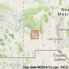
Beartooth quartzite. Quartzite with a little interbedded shale; at base in many places is a thin conglomerate containing black and white quartz pebbles an inch or more in diameter in matrix of clearly washed, fine, glassy quartz grains. Thickness 90 to 125 feet. Lies unconformably, by Colorado shale, from which it is readily distinguished, the separation being at top of uppermost quartzite bed. No fossils. Age in doubt. Tentatively classified as Upper(?) Cretaceous.
Named from Beartooth Creek, near Fort Bayard, Silver City region, [Silver City 1:125,000-scale quadrangle, 1909 ed., Grant Co.], southwestern NM.
Source: US geologic names lexicon (USGS Bull. 896, p. 135).
- Usage in publication:
-
- Beartooth Quartzite
- Modifications:
-
- Overview
- AAPG geologic province:
-
- Orogrande basin
- Basin-and-Range province
Summary:
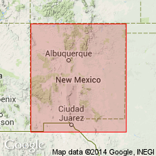
Is Lower Cretaceous formation in south-central (Orogrande basin) and southwestern (Basin-and-Range province) NM. Is basal Cretaceous sandstone in Santa Rita-Silver City area and appears lithologically similar to the type Sarten Sandstone (Lower Cretaceous) and in many respects to the Dakota? Sandstone (Lower Cretaceous) of south-central NM. Author believes Beartooth correlates directly with Sarten; Sarten, Beartooth, and Dakota? of area from Silver City east to Sacramento Mountains may all be roughly correlative units with either (1) a lower part of Early Cretaceous age and an upper part of Late Cretaceous age, or (2) a time-transgressive unit grading from Early Cretaceous age at the south into Late Cretaceous age to the north. Isopach and facies map of Lower Cretaceous strata in southwestern and south-central NM (fig 18).
Source: GNU records (USGS DDS-6; Denver GNULEX).

- Usage in publication:
-
- Beartooth Quartzite*
- Modifications:
-
- Overview
- AAPG geologic province:
-
- Basin-and-Range province
Summary:
Is oldest Cretaceous formation in Silver City-Santa Rita area, NM in Basin-and-Range province. Unconformably overlies rocks ranging in age from Precambrian to Permian; overlain with apparent conformity by Colorado Formation (Cenomanian and Turonian). May be equivalent to upper part of Mojado Formation of Zeller, Jr. (1965) in Big Hatchet Mountains, NM in Pedregosa basin. Is most likely of late Washita (early Cenomanian) age on basis of stratigraphic position dating.
Source: GNU records (USGS DDS-6; Denver GNULEX).
For more information, please contact Nancy Stamm, Geologic Names Committee Secretary.
Asterisk (*) indicates published by U.S. Geological Survey authors.
"No current usage" (†) implies that a name has been abandoned or has fallen into disuse. Former usage and, if known, replacement name given in parentheses ( ).
Slash (/) indicates name conflicts with nomenclatural guidelines (CSN, 1933; ACSN, 1961, 1970; NACSN, 1983, 2005, 2021). May be explained within brackets ([ ]).