

- Usage in publication:
-
- Witnet formation*
- Modifications:
-
- Named
- Dominant lithology:
-
- Arkose
- Shale
- AAPG geologic province:
-
- Sierra Nevada province
Summary:
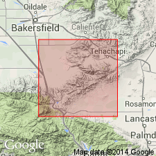
Named from Witnet Ridge north of lower Oil Canyon, Kern Co, CA. [Name Witnet formation first used by Buwalda (1934) in abstract]. Exposed chiefly along Cache Creek and lower Oil Canyon about 5 mi northeast of Monolith, Kern Co. Type section designated in lower Oil Canyon about 1 mi above its junction with Cache Creek, NW/4 sec.13 T32S R34E, Mojave and Tehachapi quads. Consists mainly of alternate beds of coarse gray arkose, locally bouldery, and of dark sandy shale. Thickness is more than 4000 ft. No fossils were found. Neither top nor base is exposed. At lower contact granitic basement rocks are thrust over it. Unconformably overlain by gently dipping Miocene strata. Age is probably early Tertiary (pre-middle Miocene).
Source: GNU records (USGS DDS-6; Menlo GNULEX).
- Usage in publication:
-
- Witnet Formation*
- Modifications:
-
- Age modified
- AAPG geologic province:
-
- Sierra Nevada province
Summary:
Age of Witnet Formation is early Tertiary based on possible correlation with the Goler Formation.
Source: GNU records (USGS DDS-6; Menlo GNULEX).
- Usage in publication:
-
- Witnet Formation
- Modifications:
-
- Areal extent
- AAPG geologic province:
-
- Sierra Nevada province
Summary:
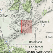
Witnet Formation has been geographically extended beyond its type area on lower Oil Canyon to include arkosic sedimentary deposits on north side of Tehachapi Mountains, west of Oak Pass, and in and around Jawbone Canyon. Samsel (1962) described arkosic sandstones in Cross Mountain area which may be correlative of Witnet.
Source: GNU records (USGS DDS-6; Menlo GNULEX).
For more information, please contact Nancy Stamm, Geologic Names Committee Secretary.
Asterisk (*) indicates published by U.S. Geological Survey authors.
"No current usage" (†) implies that a name has been abandoned or has fallen into disuse. Former usage and, if known, replacement name given in parentheses ( ).
Slash (/) indicates name conflicts with nomenclatural guidelines (CSN, 1933; ACSN, 1961, 1970; NACSN, 1983, 2005, 2021). May be explained within brackets ([ ]).