

- Usage in publication:
-
- Waupee volcanics
- Modifications:
-
- First used
- Dominant lithology:
-
- Volcanics
- AAPG geologic province:
-
- Wisconsin arch
Summary:
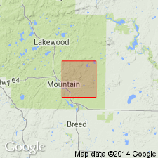
First published use as map unit in vicinity of McCaslin syncline in southeastern Forest, western Marinette, and northern Oconto Cos., WI (Lake Superior region). Name attributed to Mancuso (unpublished thesis, Univ. WI). Type locality not designated. Derivation of name not stated; apparently named from Waupee Creek. Described at field trip Stop 1 (northeast of the town of Mountain, Oconto Co.) as "well-stratified ash, striking about N 60 E and dipping almost vertical. Abundant hornblende indicates that metamorphism has reached at least the low amphibolite rank. Some silicification along the bedding is locally evident." Outcrop on Thunder River at footbridge (Stop 4) "appears to be a fine-grained water-laid ash--presumably Waupee volcanics. It weathers light grey, and superficially resembles some of the fine greywacke-quartzite of Stop 3. West of the bridge, the strike is approximately east-west, and dip about 80 deg south." Increasing deformation noted downstream (eastward); "Silicification and pyritization are also more in evidence. Quartz veins become numerous, and there are some large quartz pods with the bedding wrapped around them." Age is not stated.
Source: GNU records (USGS DDS-6; Reston GNULEX).
- Usage in publication:
-
- Waupee Volcanics*
- Modifications:
-
- Overview
- Dominant lithology:
-
- Volcanics
- Schist
- AAPG geologic province:
-
- Wisconsin arch
Summary:
First described in thesis by Mancuso (1957); here adopted for use in northeast WI in the Lake Superior region. Type area designated in T31N, R17E and adjacent areas for sporadic exposures in low hills, Oconto Co., northern WI. Mapped as interlayered biotite and amphibole schist and quartz diorite schist within shear zone. Outside of shear zone, mapped as weakly deformed metavolcanics, including felsic and minor interbedded mafic rocks and mafic lava flows. Both within and outside shear zone, metamorphosed to upper greenschist or amphibole facies. Detailed lithology, geologic map, structural interpretations. Intruded by unnamed granodiorite and granitic gneisses and by Hines Quartz Diorite (new). Locally overlain by Baldwin Conglomerate in shear zone. Is oldest unit mapped and is Early Proterozoic in age.
Source: GNU records (USGS DDS-6; Reston GNULEX).
For more information, please contact Nancy Stamm, Geologic Names Committee Secretary.
Asterisk (*) indicates published by U.S. Geological Survey authors.
"No current usage" (†) implies that a name has been abandoned or has fallen into disuse. Former usage and, if known, replacement name given in parentheses ( ).
Slash (/) indicates name conflicts with nomenclatural guidelines (CSN, 1933; ACSN, 1961, 1970; NACSN, 1983, 2005, 2021). May be explained within brackets ([ ]).