

- Usage in publication:
-
- Walcott welded tuff
- Modifications:
-
- Original reference
- Dominant lithology:
-
- Tuff
- AAPG geologic province:
-
- Snake River basin
Summary:
Pg. 23. Walcott welded tuff. Name proposed for unit that was formerly called Eagle Rock tuff (Stearns and others, 1938, USGS Water-Supply Paper 774). Eagle Rock was used as locality name at the time but, because of basaltic tuff originated at Eagle Rock vent, confusion can be avoided in present report by renaming the tuff from Walcott Lake. Four phases recognized: dark-red brittle pitchstone, fine-grained pink and gray rock honeycombed with lithophysae, hard obsidian containing spherulites, and well-bedded glass shard tuff and loose white and gray ash. Thickness 50 to 70 feet. Overlies with slight disconformity Neeley lake beds; underlies with slight disconformity tuffaceous siliceous shallow water sediment referred to as Formation A. Interpreted to represent a hot avalanche or nuee ardente. Age is Pliocene or older.
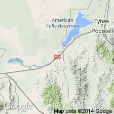
Named from Lake Walcott, where an excellent section is exposed in east bank [in vicinity of Massacre Rocks State Park], in SE/4 sec. 29, T. 8 S., R. 30 E., [Neeley 7.5-min quadrangle], Power Co., Snake River Plain, eastern ID.
[GNC remark (ca. 1960, US geologic names lexicon, USGS Bull. 1200, p. 4107): name Walcott tuff adopted by the USGS. Age is middle Pliocene.]
Source: US geologic names lexicon (USGS Bull. 1200, p. 4107, Eagle Rock entry p. 1198-1199).
- Usage in publication:
-
- Walcott tuff*
- Modifications:
-
- Areal extent
- AAPG geologic province:
-
- Snake River basin
Summary:
Pg. G16-G19. Walcott tuff. Consists of a lower white or light-gray bedded friable tuff member and an upper dark obsidian welded tuff member. Thickness 16 to 50+ feet. Conformably overlies Neeley formation. Unconformably underlies Little Creek formation; contact generally marked by a thin colluvial breccia at base of Little Creek. Age is Pliocene.
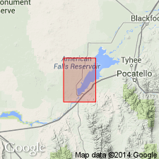
Composite section 25.7 ft thick measured in lower Ferry Hollow, in SW/4 NE/4 sec. 6, T. 8 S., R. 31 E., American Falls quadrangle, Power Co., southern ID.
Type locality stated to be in cliff on west side of Snake River below railroad trestle at American Falls, Power Co., southern ID.
Source: Publication.
- Usage in publication:
-
- Walcott Tuff*
- Modifications:
-
- Geochronologic dating
- AAPG geologic province:
-
- Snake River basin
Summary:
Pg. 241. Walcott Tuff. Samples from glassy rhyolitic welded tuff near American Falls, Power Co., eastern Snake River Plain, southern ID, yielded K-Ar age of about 6.2 Ma; [North American land mammal age Hemphillian; =Pliocene (Evernden and others, 1964, Amer. Jour. Sci., v. 262, p. 145-198), =Miocene (Berggren, 1972, Lethaia, v. 5, no. 2, p. 195-215)]. Overlies Neeley Formation. Older than Little Creek Formation (4.8 +/-0.3 Ma). Report includes sample locality map, schematic stratigraphic-chronologic diagram, table of K-Ar ages.
Source: Publication.
- Usage in publication:
-
- Walcott Tuff
- Modifications:
-
- Reference
- Geochronologic dating
- AAPG geologic province:
-
- Snake River basin
Summary:
[Walcott Tuff of Heise Group. Not synopsized to date.]
Source: NA
For more information, please contact Nancy Stamm, Geologic Names Committee Secretary.
Asterisk (*) indicates published by U.S. Geological Survey authors.
"No current usage" (†) implies that a name has been abandoned or has fallen into disuse. Former usage and, if known, replacement name given in parentheses ( ).
Slash (/) indicates name conflicts with nomenclatural guidelines (CSN, 1933; ACSN, 1961, 1970; NACSN, 1983, 2005, 2021). May be explained within brackets ([ ]).