

- Usage in publication:
-
- Waihu drift
- Modifications:
-
- Named
- Dominant lithology:
-
- Drift
- AAPG geologic province:
-
- Hawaii
Summary:
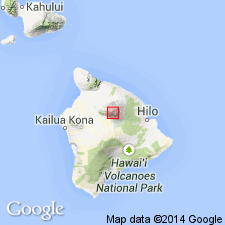
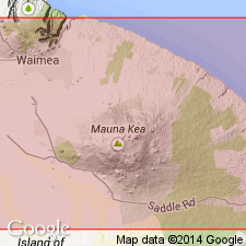
Named for exposures near Waihu Springs at 9700 ft elev. west of Pohakuloa Gulch, Mauna Kea Volcano, Island of Hawaii, HI as one of four drifts (youngest to oldest: Makanaka, Waihu, Pohakuloa and pre-Pohakuloa in Pohakuloa and Waikahalulu gulches). Comprised of dark-gray to black and purple fine-grained rounded chunks of basalt derived from glacial drift of Waihu stage of glaciation. Believed to be correlated with Illinoian stage in North America and Riss stage in Europe.
Source: GNU records (USGS DDS-6; Menlo GNULEX).
- Usage in publication:
-
- Waihu fanglomerate*
- Modifications:
-
- Redescribed
- AAPG geologic province:
-
- Hawaii
Summary:
Type locality: in Pohakuloa gulch [19 deg 47' 00"N, 155 deg 30' 31"W, Ahumoa 7.5' quad, Island of Hawaii]. Renamed Waihu fanglomerate. "The Waihu fanglomerate with its well-developed bedding might be outwash of an earlier glacial stage. but it is certainly not drift as described by Wentworth and Powers [1941]" p.271. Deposit forms fans 100 ft thick at 9000 and 9750 ft elev. between Waikahalulu and Pohakuloa Gulches. On upper slopes is overlain by pre-Makanaka lava flows and several places is overlain by Makanaka outwash. Negative evidence for early Wisconsin age is absence of shore lines about 25-foot level on pre-Waihu lavas on western coast of Mauna Kea in contrast to shore lines extending 250 ft above sea level on Kohala Mountain.
Source: GNU records (USGS DDS-6; Menlo GNULEX).
- Usage in publication:
-
- Waihu Formation
- Modifications:
-
- Redescribed
- AAPG geologic province:
-
- Hawaii
Summary:
Shown as next to oldest formation of the Laupahoehoe Group comprising glacial drifts of Waihu sediments and "intra-Waihu lava flows". Overlies Liloe Formation (new) and underlies Hanaipoe Formation (new) both of Laupahoehoe Group. Assigned Pleistocene age.
Source: GNU records (USGS DDS-6; Menlo GNULEX).
- Usage in publication:
-
- Waihu Formation
- Modifications:
-
- Geochronologic dating
- AAPG geologic province:
-
- Hawaii
Summary:
Sedimentary rocks form belt of subdued end moraines exposed mainly in southwest quadrant of volcano at 3000 m level. Includes clasts from Hopukani Formation and Liloe Formation. K-Ar ages range from 136,000 +/-14,000 to 113,000 +/-15,000 yr B.P.
Source: GNU records (USGS DDS-6; Menlo GNULEX).
- Usage in publication:
-
- Waihu Formation
- Modifications:
-
- Geochronologic dating
Summary:
Sedimentary deposits in Waihu drift of Wentworth and Powers (1941) and in Waihu fanglomerate of Stearns (1945) here redesignated Waihu Formation of Laupahoehoe Group. Reference locality between 2,585 and 3065 m elev. in walls of unnamed gulch behind U.S. Army Pohakuloa Training Area. Is interbedded with Waikahalulu Formation. [Liloe and Hanaipoe Formations are herein considered stages.] The K-Ar ages for unit are associated with Poliahuan stage ranging from 174,400 +/-26,500 through 171,900 +/-2800 yr B.P.
Source: GNU records (USGS DDS-6; Menlo GNULEX).

- Usage in publication:
-
- Waihu Glacial Member*
- Modifications:
-
- Revised
- AAPG geologic province:
-
- Hawaii
Summary:
Waihu Formation of Laupahoehoe Group (Porter, 1974) reduced in rank and named as older glacial member of Laupahoehoe Volcanics. Reference localities in Pohakuloa Gulch and near Waihu Spring. Mainly conglomerate and diamictite. Exposed thickness about 30 m. Intercalated with Waikahalulu Volcanic Member of Laupahoehoe Volcanics.
Source: GNU records (USGS DDS-6; Menlo GNULEX).
- Usage in publication:
-
- Waihu Glacial Member*
- Modifications:
-
- Revised
- AAPG geologic province:
-
- Hawaii
Summary:
Unit is removed from Laupahoehoe Volcanics and reassigned to Hamakua Volcanics. Intercalated with Liloe Spring Volcanic Member (new) (Hamakua Volcanics). Age is Pleistocene [bracketed between approximately 85 and 70 ka, K-Ar ages of basalt of Liloe Spring Volcanic Member above and below unit].
Source: GNU records (USGS DDS-6; Menlo GNULEX).
For more information, please contact Nancy Stamm, Geologic Names Committee Secretary.
Asterisk (*) indicates published by U.S. Geological Survey authors.
"No current usage" (†) implies that a name has been abandoned or has fallen into disuse. Former usage and, if known, replacement name given in parentheses ( ).
Slash (/) indicates name conflicts with nomenclatural guidelines (CSN, 1933; ACSN, 1961, 1970; NACSN, 1983, 2005, 2021). May be explained within brackets ([ ]).