

- Usage in publication:
-
- Victoria quartzite*
- Modifications:
-
- Named
- Dominant lithology:
-
- Limestone
- AAPG geologic province:
-
- Great Basin province
Summary:
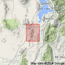
Named for the Victoria mine, T10S, R2W, Juab Co, UT in the Great Basin province. No type locality designated. Included as part of Godiva limestone by Tower and Smith (1899). Occurs as a narrow band in central part of Tintic mining district. Geologic map. Consists of alternating beds of limy quartzite and siliceous, yellow to brown, mostly fine to medium grained limestone. Some beds are conglomeratic. Limestone pebbles typically of Bluebell dolomite. Matrix of conglomerate is dolomitic with varying amounts of quartz grains. The thickest section of Victoria is below Mammoth Bluffs where unit is 85 ft thick and composed of gray limestone, sandy limestone, and quartzite. No fossils found. Unconformably over Bluebell dolomite (named). Underlies Gardner dolomite (new). Of Early Mississippian age.
Source: GNU records (USGS DDS-6; Denver GNULEX).

- Usage in publication:
-
- Victoria formation*
- Modifications:
-
- Revised
- Overview
- AAPG geologic province:
-
- Wasatch uplift
Summary:
Redefined to include the original Victoria of Loughlin (1919) plus a 50-75 ft sequence of mottled, coarse-grained dolomites that were formerly assigned to Gardner dolomite, a term abandoned in this report. The revised Victoria is about 280 ft thick. A section 278 ft thick measured in E1/2 SE1/4 sec 33, T9S, R2W, Utah Co, Wasatch uplift, described where it overlies Bluebell dolomite and underlies Pinyon Peak limestone. Has yielded no identifiable fossils. Age of Late Devonian assigned on basis of position between two dated Late Devonian formations. Cross sections. Geologic map.
Source: GNU records (USGS DDS-6; Denver GNULEX).
For more information, please contact Nancy Stamm, Geologic Names Committee Secretary.
Asterisk (*) indicates published by U.S. Geological Survey authors.
"No current usage" (†) implies that a name has been abandoned or has fallen into disuse. Former usage and, if known, replacement name given in parentheses ( ).
Slash (/) indicates name conflicts with nomenclatural guidelines (CSN, 1933; ACSN, 1961, 1970; NACSN, 1983, 2005, 2021). May be explained within brackets ([ ]).