

- Usage in publication:
-
- Upham dolomite
- Modifications:
-
- Named
- Dominant lithology:
-
- Dolomite
- AAPG geologic province:
-
- Orogrande basin
Summary:
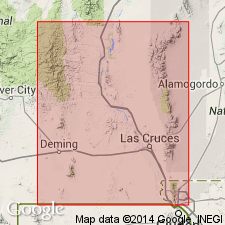
Named as one of four formations of Montoya group. Type locality near Sierrite Mine at head of Cable Canyon, NW1/4 sec 10, T16S, R4W, Caballo Mountains, Sierra Co, NM in Orogrande basin. Section measured. Occurs wherever base of Montoya is exposed, especially in west-facing escarpments of main part of Caballo Mountains, in Mud Springs Mountains, north Red Hills, south Red Hills, Red House Mountain, Derry Hills, and east of Truth or Consequences. Consists of microcrystalline to coarsely crystalline dolomite, medium-gray to dark-gray on fresh exposure. Locally no sharp separation from underlying Cable Canyon sandstone (new); includes detrital quartz grains identical to Cable Canyon. Sand decreases upward in quantity; upper part contains no sand. General absence of chert contrasts strongly with overlying Aleman formation (new). Where chert is present occurs as scattered, irregularly shaped nodules or thin bands. Locally coarse textured with excellent intergranular porosity. Very few fossils. Is of Cincinnatian, Late Ordovician age.
Source: GNU records (USGS DDS-6; Denver GNULEX).
- Usage in publication:
-
- Upham Member
- Modifications:
-
- Areal extent
- Overview
- AAPG geologic province:
-
- Pedregosa basin
Summary:
Is one of four members of Montoya Dolomite. Was studied in detail only in Mescal Canyon, where a section 56 ft thick was measured and described. Section is in NE1/4 SE1/4 sec 29, T30S, R15W, Hidalgo Co, NM, Pedregosa basin. Overlies Cable Canyon Member of Montoya. Underlies Aleman Member of Montoya. Brachiopod shells and echinoderm columnals found in top strata. Assigned to the Champlainian Series of the Ordovician.
Source: GNU records (USGS DDS-6; Denver GNULEX).

- Usage in publication:
-
- Upham Dolomite*
- Modifications:
-
- Mapped 1:24k
- Dominant lithology:
-
- Dolomite
- AAPG geologic province:
-
- Pedregosa basin
Summary:
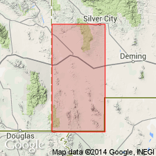
Upham Dolomite of Montoya Group. Mapped in Big Hatchet Mountains, Hidalgo County, southwestern New Mexico. Medium-gray, medium- to coarse-grained, medium-bedded, slightly cherty dolomite that weathers mottled light and dark gray. Thickness about 56 feet (17 m). Occurs above Cable Canyon Sandstone and below Aleman Dolomite, both of Montoya Group. Age is Middle Ordovician.
Source: Publication.
For more information, please contact Nancy Stamm, Geologic Names Committee Secretary.
Asterisk (*) indicates published by U.S. Geological Survey authors.
"No current usage" (†) implies that a name has been abandoned or has fallen into disuse. Former usage and, if known, replacement name given in parentheses ( ).
Slash (/) indicates name conflicts with nomenclatural guidelines (CSN, 1933; ACSN, 1961, 1970; NACSN, 1983, 2005, 2021). May be explained within brackets ([ ]).