

- Usage in publication:
-
- Uncle Sam porphyry
- Modifications:
-
- Named
- Dominant lithology:
-
- Quartz latite
- AAPG geologic province:
-
- Pedregosa basin
Summary:
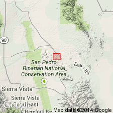
Forms Three Brothers and Uncle Sam Hills (source of name?) in the Tombstone district, Cochise Co, AZ in Pedregosa basin. No type locality designated. Is a buff or rusty-brown quartz latite porphyry. Phenocrysts--in order of decreasing abundance: plagioclase, quartz, biotite, and hornblende--are small, probably less than 1/4 in long. Is characteristically blotchy and has uneven texture. Groundmass is devitrified glass. Chemical analyses, Geologic map. Intrusive into Bisbee group. Of Comanche, Cretaceous age.
Source: GNU records (USGS DDS-6; Denver GNULEX).
- Usage in publication:
-
- Uncle Sam porphyry*
- Modifications:
-
- Age modified
- Overview
- AAPG geologic province:
-
- Pedregosa basin
Summary:
Age changed from Late Cretaceous or early Tertiary to probably early Tertiary, although its age is uncertain within wide limits. Intrusive into rocks as young as the Cretaceous or early Tertiary Bronco volcanics (new). Intruded by Schieffelin granodiorite, also probable Tertiary age. Is younger than most of the deformational events of the area. Unconformably overlain by Gila conglomerate of late Pliocene age. Occurs in Ts19, 20, 21, and 22E, Tombstone Hills area, Cochise Co, AZ in Pedregosa basin as masses and as small dikes and sills. Is a gray, quartz-poor latite porphyry that has crystals of plagioclase, biotite, and subordinate hornblende that range from 1 mm to 8 mm long. Quartz forms smaller and fewer phenocrysts. The groundmass is aphanitic and near contacts is glassy.
Source: GNU records (USGS DDS-6; Denver GNULEX).
- Usage in publication:
-
- Uncle Sam Porphyry*
- Modifications:
-
- Geochronologic dating
- AAPG geologic province:
-
- Basin-and-Range province
Summary:
Fresh biotite from unit collected about 2 mi south of AZ Hwy 82 and 3 mi west of San Pedro River, Basin-and-Range province, dated by potassium-argon method as 71.9 +/-2.4 m.y. (R. F. Marvin, H. H. Mehnert, and V. M. Merritt, written commun., 1968). Compared to welded tuff member of Salero Formation of late Late Cretaceous age.
Source: GNU records (USGS DDS-6; Denver GNULEX).
- Usage in publication:
-
- Uncle Sam Porphyry*
- Modifications:
-
- Geochronologic dating
- AAPG geologic province:
-
- Pedregosa basin
Summary:
Samples collected from Uncle Sam Porphyry in the Tombstone area, Cochise Co., AZ. Age is Late Cretaceous. Recalculated K-Ar age is 73.5 +/-2.8 Ma.
Source: Modified from GNU records (USGS DDS-6; Denver GNULEX).
- Usage in publication:
-
- Uncle Sam Tuff*
- Modifications:
-
- Redescribed
- Dominant lithology:
-
- Tuff
- Dacite
- AAPG geologic province:
-
- Pedregosa basin
Summary:
Redescribed to pale-brown to light-gray, moderately to densely welded dacitic tuff containing sparse to locally abundant xenoliths of andesite, rhyolite, and sedimentary rocks and abundant phenocrysts of plagioclase and biotite. Maximum thickness in quad is about 600 m. Thicker to east in Tombstone quad. Late Cretaceous age (73.5 +/-2.8 Ma).
Source: GNU records (USGS DDS-6; Denver GNULEX).
For more information, please contact Nancy Stamm, Geologic Names Committee Secretary.
Asterisk (*) indicates published by U.S. Geological Survey authors.
"No current usage" (†) implies that a name has been abandoned or has fallen into disuse. Former usage and, if known, replacement name given in parentheses ( ).
Slash (/) indicates name conflicts with nomenclatural guidelines (CSN, 1933; ACSN, 1961, 1970; NACSN, 1983, 2005, 2021). May be explained within brackets ([ ]).