

- Usage in publication:
-
- Vester Formation*
- Modifications:
-
- Named
- Dominant lithology:
-
- Conglomerate
- Shale
- Tuff
- AAPG geologic province:
-
- Blue Mountains province
Summary:
Vester Formation. Formal proposal of name. At type locality, comprises (ascending) about 6,000 feet of pebbly conglomerate and interbedded shale, about 1,000 feet of water-laid andesitic tuff, and 1,000 feet or more of black shale. About 2 miles north of type locality and 1 mile west of Buck Creek, interlayered ophitic basalt flows, flow breccia, and chert are included in basal part of formation. Lies unconformably on Paleozoic schist and greenstone and Mesozoic serpentine, diorite, and gabbroic rocks. North of Murderers Creek, major angular unconformity separates the Vester from overlying Fields Creek Formation; elsewhere, the Vester is in fault contact with younger rocks.
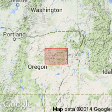
Type locality: along lower part of Vester Creek, the second north-flowing creek west of South Fork of Deer Creek, in north-central part of Izee quadrangle, Grant Co., northeastern OR.
Source: US geologic names lexicon (USGS Bull. 1350, p. 797).
- Usage in publication:
-
- Vester Formation*
- Modifications:
-
- Mapped
- AAPG geologic province:
-
- Blue Mountains province
Summary:
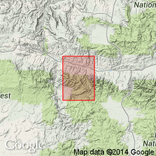
Vester Formation. Mapped in Aldrich Mountain quadrangle, Grant County, northeastern Oregon. Consists of graywacke with some conglomerate and shale. Separated from Fields Creek Formation of Aldrich Mountains Group (both new) by angular unconformity. Age is Late Triassic.
Source: US geologic names lexicon (USGS Bull. 1350, p. 797).
- Usage in publication:
-
- Vester Formation
- Modifications:
-
- Overview
- AAPG geologic province:
-
- Blue Mountains province
Summary:
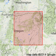
Pg. 55. Vester Formation. Defined by Brown and Thayer (1966, USGS Misc. Inv. Ser. Map I-447). Exposures in lower Vester Creek, in north-central part of Izee quadrangle, central Oregon, are designated as type locality. Forms extensive northwest-trending exposures between Paulina basin and Bear Valley basin in the pre-Tertiary uplands northeast of Izee, central Oregon.
Vester Formation consists of (in ascending order) 6,000 feet of pebbly conglomerate and interbedded black shale, 1,000 feet of water-laid andesitic tuff, and 1,000 feet of black shale. Two miles north of type locality, lower part(?) of formation consists of 1,000 feet of interlayered black shale, ophitic basalts, and breccias.
Vester Formation unconformably overlies Paleozoic rocks; unconformably underlies Aldrich Mountain Group. Is probably northward equivalent of Dickinson and Vigrass' (1965) Begg and Brisbois Formations of the Suplee-Izee district. Age is no older than middle Late Triassic (late Karnian).
See also:
Dickinson, W.R., and Vigrass, L.W., 1965, "Geology of the Suplee-Izee area, Cook, Grant, and Harney Counties, Oregon," Oregon Dept. Geol. and Min. Ind. Bull., no. 58, 109 p., geol. map (scale 1:42,000).
Source: Publication.
- Usage in publication:
-
- Vester Formation*
- Modifications:
-
- Revised
- AAPG geologic province:
-
- Blue Mountains province
Summary:
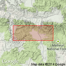
Vester Formation. Divided into (ascending): Begg Member and Brisbois Member (both revised). Unconformably overlies Paleozoic rocks; unconformably underlies Rail Cabin Argillite. Age is Late Triassic.
Source: Changes in stratigraphic nomenclature, 1977 (USGS Bull. 1457-A, p. A82-A83).
For more information, please contact Nancy Stamm, Geologic Names Committee Secretary.
Asterisk (*) indicates published by U.S. Geological Survey authors.
"No current usage" (†) implies that a name has been abandoned or has fallen into disuse. Former usage and, if known, replacement name given in parentheses ( ).
Slash (/) indicates name conflicts with nomenclatural guidelines (CSN, 1933; ACSN, 1961, 1970; NACSN, 1983, 2005, 2021). May be explained within brackets ([ ]).