

- Usage in publication:
-
- Twentymile sandstone member*
- Modifications:
-
- Named
- Dominant lithology:
-
- Sandstone
- AAPG geologic province:
-
- Green River basin
Summary:
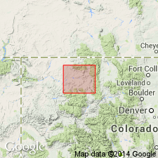
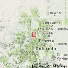
Named as a member of Mesaverde formation for its development in and around Twentymile Park, Routt Co, CO in the Greater Green River basin. No type locality designated. Geologic map. Mesaverde mapped as an undivided unit. Consists of ledge-making, massive, friable white sandstone about 75 ft thick. Overlies and underlies unnamed parts of the Mesaverde. Its base is about 2,975 ft above the base of the Mesaverde and about 1,000 ft above the top of the Trout Creek sandstone member of Mesaverde. Trout Creek is also named in this report. Cretaceous age. Trout Creek and Twentymile sandstone members not mapped on geologic map.
Source: GNU records (USGS DDS-6; Denver GNULEX).
- Usage in publication:
-
- Twentymile sandstone member*
- Modifications:
-
- Revised
- AAPG geologic province:
-
- Green River basin
Summary:
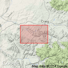
Sandstone named Twentymile sandstone traced into Yampa River area, Moffat Co, CO in the Greater Green River basin, where it is assigned as a member of Williams Fork formation (named) of Mesaverde group. Lies about 900 to 1,050 ft above base of formation. Cretaceous age.
Source: GNU records (USGS DDS-6; Denver GNULEX).
- Usage in publication:
-
- Twentymile Sandstone Member*
- Modifications:
-
- Overview
- AAPG geologic province:
-
- Green River basin
Summary:
Correlation of Upper Cretaceous Pierre Shale (and its Hygiene, Terry, Rocky Ridge, and Larimer Sandstone Members) near Boulder, CO with Pierre Shale (and its Sharon Springs, Kremmling, Muddy Buttes, Hygiene, Carter and Gunsight Pass Members) near Kremmling, CO, and with upper part of Mancos Shale (and its Morapos and Loyd Sandstone Members) and with Iles Formation (and its Tow Creek and Trout Creek Sandstone Members) and Williams Fork Formation (and its Twentymile Sandstone Member); the last two are formations of Mesaverde Group of Hamilton area, Moffat Co in Greater Green River basin shown on fig. 2.
Source: GNU records (USGS DDS-6; Denver GNULEX).
For more information, please contact Nancy Stamm, Geologic Names Committee Secretary.
Asterisk (*) indicates published by U.S. Geological Survey authors.
"No current usage" (†) implies that a name has been abandoned or has fallen into disuse. Former usage and, if known, replacement name given in parentheses ( ).
Slash (/) indicates name conflicts with nomenclatural guidelines (CSN, 1933; ACSN, 1961, 1970; NACSN, 1983, 2005, 2021). May be explained within brackets ([ ]).