

- Usage in publication:
-
- Tropico group*
- Modifications:
-
- Named
- Dominant lithology:
-
- Fanglomerate
- Basalt
- Quartz latite
- Tuff
- Limestone
- AAPG geologic province:
-
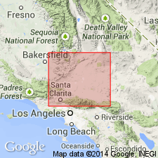
- Mojave basin
Summary:
Named after Mojave-Tropico road that traverses type section which is designated as exposures in Rosamond Hills within 0.5 mi west of Mojave-Tropico road 1 to 2 mi north of Tropico mines, NE/4 sec.2 T9N R13W, Rosamond 15' quad, Kern Co, CA. Formerly called Rosamond series by Hershey (1902). Divided into units recognizable only in local areas: (1) Gem Hill formation (Miocene?) and Fiss fanglomerate (Miocene?) at Antelope Buttes, (2) Gem Hill formation (Miocene?) (and Bobtail quartz latite member (Miocene?)) and Fiss fanglomerate at Rosamond Hills, (3) Gem Hill formation (Miocene?) (and Bobtail quartz latite member (Miocene?) and Bissell formation (Miocene or Pliocene) in hills north of Bissell, (4) unnamed lower part, Saddleback basalt (Pliocene?) and unnamed upper part in Kramer borate area, (5) unnamed lower part, Red Buttes quartz basalt (Pliocene?), and unnamed upper part in Kramer Hills. [all new]. In general lower part is tuffaceous strata of rhyolitic composition and upper part is coarse stream-laid or fine lacustrine sedimentary rocks and mafic lava flows. Maximum thickness is 2800 ft. Overlies eroded surface of granitic basement rocks. Unconformably underlies Quaternary alluvium. Group is nonfossiliferous except for diatoms in limestone in upper part, 2 mi west of Castle Butte which suggest early Pliocene(?) age. Stratigraphic evidence suggests lower part may be as old as middle or possibly early Miocene(?) age.
Source: GNU records (USGS DDS-6; Menlo GNULEX).
- Usage in publication:
-
- Tropico Group*
- Modifications:
-
- Age modified
- AAPG geologic province:
-
- Mojave basin
Summary:
Age of group is Oligocene(?) and Miocene. Seven measured sections of unnamed lower part of Tropico Group included. Age of lower unnamed part shown as Oligocene(?) and Miocene(?); age of upper unnamed part shown as Miocene on geologic sketch map of Kramer borate district.
Source: GNU records (USGS DDS-6; Menlo GNULEX).
For more information, please contact Nancy Stamm, Geologic Names Committee Secretary.
Asterisk (*) indicates published by U.S. Geological Survey authors.
"No current usage" (†) implies that a name has been abandoned or has fallen into disuse. Former usage and, if known, replacement name given in parentheses ( ).
Slash (/) indicates name conflicts with nomenclatural guidelines (CSN, 1933; ACSN, 1961, 1970; NACSN, 1983, 2005, 2021). May be explained within brackets ([ ]).