

- Usage in publication:
-
- Tortilla Quartz Diorite*
- Modifications:
-
- Named
- Geochronologic dating
- Dominant lithology:
-
- Quartz diorite
- AAPG geologic province:
-
- Basin-and-Range province
Summary:
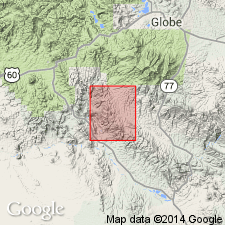
Named for widespread exposures in the Tortilla Mountains. Type section is in sec 2, T4S, R13E, north of Gila River and west of Mineral Creek, Pinal Co, AZ in Basin-and-Range province. Occurs as stock-like masses in southern half of quad. Is cut by Cretaceous and Tertiary rhyodacite porphyry. Intrudes all rocks of Naco Limestone and older age. Was called Sonora diorite, a local informal term previously. Is a quartz diorite. The composition ranges from pyroxene-hornblende diorite through biotite-hornblende quartz diorite (tonalite). K-Ar ages of 71 +/-2 m.y. and 83 +/-2 m.y. obtained from biotite and hornblende respectively. Geologic map.
Source: GNU records (USGS DDS-6; Denver GNULEX).
For more information, please contact Nancy Stamm, Geologic Names Committee Secretary.
Asterisk (*) indicates published by U.S. Geological Survey authors.
"No current usage" (†) implies that a name has been abandoned or has fallen into disuse. Former usage and, if known, replacement name given in parentheses ( ).
Slash (/) indicates name conflicts with nomenclatural guidelines (CSN, 1933; ACSN, 1961, 1970; NACSN, 1983, 2005, 2021). May be explained within brackets ([ ]).