

- Usage in publication:
-
- Tonzona group*
- Modifications:
-
- Named
- Dominant lithology:
-
- Argillite
- Chert
- Graywacke
- AAPG geologic province:
-
- Alaska Southwestern region
- Alaska Southern region
- Alaska East-Central region
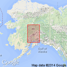
Summary:
Named for Tonzona River, Alaska Range, southwestern and southern AK. Tonzona Group typically occurs in basin of river. Group forms broken belt stretching along inland front of Alaska Range and is also recognized along lower Tanana and north of Tanana, east-central AK. Consists of black, red, green, and blue argillites and variegated cherts with some graywackes. Is 4000 to 5000 ft thick. Separated from older Tatina group (new) by fault. Unconformably (?) underlies limestone of Middle Devonian age. Assigned Silurian or Devonian age on map legend.
Source: GNU records (USGS DDS-6; Menlo GNULEX).
For more information, please contact Nancy Stamm, Geologic Names Committee Secretary.
Asterisk (*) indicates published by U.S. Geological Survey authors.
"No current usage" (†) implies that a name has been abandoned or has fallen into disuse. Former usage and, if known, replacement name given in parentheses ( ).
Slash (/) indicates name conflicts with nomenclatural guidelines (CSN, 1933; ACSN, 1961, 1970; NACSN, 1983, 2005, 2021). May be explained within brackets ([ ]).