

- Usage in publication:
-
- Tidal Formation*
- Modifications:
-
- Named
- Biostratigraphic dating
- Dominant lithology:
-
- Argillite
- AAPG geologic province:
-
- Alaska Southeastern region
Summary:
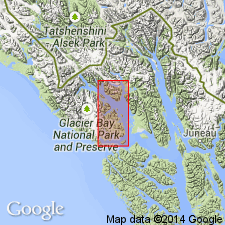
Typical section: southwest flank of the 3,594 ft peak 2.8 miles southeast of the eastern end of Tidal Inlet, southeast Alaska. Widely distributed in southern part Mt Fairweather D-1 quad and few areas of southeast corner D-2 quad. Mainly well-indurated fine-grained argillite. Lower contact not recognized; underlies Pyramid Peak Limestone with apparent conformity in most places. Thickness varies up to 5,500 ft thick. Contains few fossils. Fossils from near Sandy Cove (from rocks included in Tidal Formation but not conclusively) are corals (FAVOSITES, LEPTOCOELIA, COELOSPIRA) that are elsewhere associated with definite Late Silurian brachiopods. On basis of meager evidence, age is Late Silurian.
Source: GNU records (USGS DDS-6; Menlo GNULEX).
For more information, please contact Nancy Stamm, Geologic Names Committee Secretary.
Asterisk (*) indicates published by U.S. Geological Survey authors.
"No current usage" (†) implies that a name has been abandoned or has fallen into disuse. Former usage and, if known, replacement name given in parentheses ( ).
Slash (/) indicates name conflicts with nomenclatural guidelines (CSN, 1933; ACSN, 1961, 1970; NACSN, 1983, 2005, 2021). May be explained within brackets ([ ]).