

- Usage in publication:
-
- Temple Bar conglomerate
- Modifications:
-
- Named
- Dominant lithology:
-
- Conglomerate
- Sand
- Gravel
- AAPG geologic province:
-
- Plateau sedimentary province
Summary:
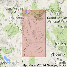
Named for Temple Bar, near the mouth of Virgin River in Mohave Co, AZ. No type locality designated. Occurs in the Colorado and other valleys of western AZ in the Plateau sedimentary province, filling the low places generally to an altitude of 3,000 ft or more. At Temple Bar consists of slightly consolidated sand and gravel exposed in nearly perpendicular cliffs, in which are included sheets of basalt. Is evidently a river deposit where exposed along the Colorado, but merges laterally in some places into deposits of angular mountain wash, and possibly into lacustrine deposits in others. Rests unconformably on Greggs breccia (new) and older formations; unconformably underlies Chemehuevis gravel (new). Geologic maps. Cross section. No fossils found in the conglomerate, and there is presently no means known to definitely correlate this unit with other formations. "Apparently belong" to "the Pleistocene epoch of the Quaternary."
Source: GNU records (USGS DDS-6; Denver GNULEX).
- Usage in publication:
-
- Temple Bar conglomerate*
- Modifications:
-
- Not used
Summary:
Name not used. Name was applied to most of the deformed valley deposits of northwest AZ. Some of these deposits are assigned to the newly named Chapin Wash formation and to the Sandtrap conglomerate, and to older deposits named Artillery formation in this report.
Source: GNU records (USGS DDS-6; Denver GNULEX).
For more information, please contact Nancy Stamm, Geologic Names Committee Secretary.
Asterisk (*) indicates published by U.S. Geological Survey authors.
"No current usage" (†) implies that a name has been abandoned or has fallen into disuse. Former usage and, if known, replacement name given in parentheses ( ).
Slash (/) indicates name conflicts with nomenclatural guidelines (CSN, 1933; ACSN, 1961, 1970; NACSN, 1983, 2005, 2021). May be explained within brackets ([ ]).