

- Usage in publication:
-
- Tarratine formation*
- Modifications:
-
- Named
- Biostratigraphic dating
- Dominant lithology:
-
- Sandstone
- Siltstone
- Slate
- Quartzite
- Limestone
- AAPG geologic province:
-
- New England province
Summary:
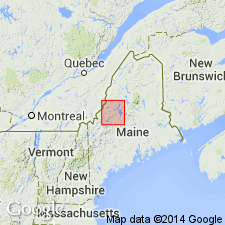
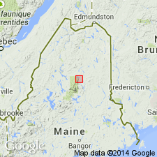
Pg. 156 (fig. 16), 165-169, pl. 34. Tarratine formation. Occurs in northern Somerset and western Piscataquis Counties, Maine. Main body consists chiefly of interbedded blue-gray, dark-brown- to gray-weathering, well-indurated sandstone; black, rusty- or gray- to dark-gray-weathering siltstone; and some thin beds of dark-gray, gray- to dark-brown-weathering slate. Thick beds form cliffs bordering Enchanted Pond and slopes of Hedgehog Mountain in [Spencer Lake] 15-min quadrangle. Formation includes Misery quartzite member (new) near top in about half of area mapped and a sandy limestone unit, McKenney Ponds limestone member (new), locally at base. Thickness as much as 10,000 feet. Southeast and northwest of trough of Moose River synclinorium the Tarratine thins rapidly and intergrades with Seboomook formation. Southwest of Spencer Lake and northeast from Big Duck Cove, the formation also diminishes rapidly. Conformably underlies Kineo volcanic member of Tomhegan formation (new). Gradationally overlies Seboomook; contact placed where cyclicly layered shale and sandstone form more than 50 percent of the exposure. Age is Early Devonian (Oriskany), based on presence of BEACHIA, MUTATIONELLA, and GLOBOTHYRIS fossils. Report includes geologic map and correlation chart.
Type section: along right-of-way of Canadian Pacific RR tracks between Tarratine, on west side of Misery Ridge, and Somerset Junction on east side of the ridge, Brassau Lake 15-min quadrangle, Somerset Co., west-central ME. Named for Tarratine railroad stop.
Source: Publication; US geologic names lexicon (USGS Bull. 1350, p. 747); GNU records (USGS DDS-6; Reston GNULEX).
- Usage in publication:
-
- Tarratine Formation*
- Modifications:
-
- Overview
- AAPG geologic province:
-
- New England province
Summary:
Pg. F9. Matagamon Sandstone is considered to be a sandstone lens similar to the Tarrantine Formation.
Source: US geologic names lexicon (USGS Bull. 1350, p. 747)

- Usage in publication:
-
- Tarratine Formation*
- Modifications:
-
- Age modified
- Biostratigraphic dating
- AAPG geologic province:
-
- New England province
Summary:
Age is refined to Early Devonian, late Siegenian (Oriskanian) based on complex shelly fauna in main body at approx. 80 localities in Long Pond, Spencer Lake, and Pierce Pond 15-min quads, as well as approx. 65 other localities in the Moose River synclinorium to the east. Contains LEPTOCOELIA FLABELLITES (Boucot and Heath, 1969). Shelly fauna and conodonts found at three localities in McKenney Ponds Limestone Member near McKenny Ponds in Pierce Pond quad yield late Siegenian (Oriskanian) age (Boucot and Heath, 1969).
Source: GNU records (USGS DDS-6; Reston GNULEX).
For more information, please contact Nancy Stamm, Geologic Names Committee Secretary.
Asterisk (*) indicates published by U.S. Geological Survey authors.
"No current usage" (†) implies that a name has been abandoned or has fallen into disuse. Former usage and, if known, replacement name given in parentheses ( ).
Slash (/) indicates name conflicts with nomenclatural guidelines (CSN, 1933; ACSN, 1961, 1970; NACSN, 1983, 2005, 2021). May be explained within brackets ([ ]).