

- Usage in publication:
-
- Tansill formation
- Modifications:
-
- Original reference
- AAPG geologic province:
-
- Permian basin
Summary:
See also DeFord IN Addison Young, Max David, and E.A. Wahlstrom, 1939, AAPG Bull., v. 23, no. 10, p. 1551. Tansill formation in Whitehorse group, name proposed by DeFord, Riggs, and Wills. [Age is Late Permian (Guadalupe).]
Source: US geologic names lexicon (USGS Bull. 1200, p. 3821-3822).
- Usage in publication:
-
- Tansill formation
- Modifications:
-
- Principal reference
- Dominant lithology:
-
- Limestone
- Silt
- Anhydrite
- AAPG geologic province:
-
- Permian basin
Summary:
Pg. 1713-1728. Tansill formation of Whitehorse group. Presentation of formal definition of Tansill formation and detailed measurement and description of section at type locality. Thickness 123.5 feet at type locality; here formation is divided into 13 units (I to XIII, ascending); units VIII, IX, and X inclusive are termed Ocotillo member. Formation is pre-Salado. Formation is a body of limestone, silt, and anhydrite that forms widespread layer of earth's crust in southeastern New Mexico and West Texas. Limestone on south and west grades into anhydrite on north and east; limestone lies around rim of Delaware basin. Time horizon at top of Tansill limestone can be traced basinward where it becomes top of Capitan reef dipping steeply downward 1,500 feet into basin --where it becomes in turn top of Deware Mountain group; this horizon can also be traced lagoonward where it becomes top of Tansill anhydrite and is in most places somewhat below horizon known as "base of the salt." The horizon that forms top of Tansill formation is boundary between Guadalupe and Ochoa series. In this region, the Tansill is top formation of Whitehorse group of Guadalupe series. Time horizon at base is top of the Yates. Lang's (1937) Three Twins member of Chalk Bluff formation seems to include both the Tansill formation and the Yates sand; but, if so, the two units are described as intergradational, and superposition of Tansill and Yates is not clearly recognized; Lang's Chalk Bluff formation is essentially the Whitehorse group of subsurface geologists. [Age is Late Permian (Guadalupe).]
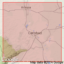
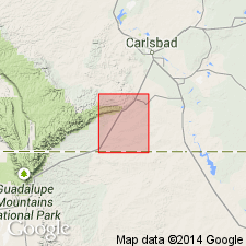
Type locality: on Carlsbad-Artesia Highway (U.S. 285), 3.7 mi from Eddy County Courthouse in Carlsbad, in W/2 sec. 26, T. 21 S., R. 26 E., of NM Principal Meridian, [Carlsbad West 7.5-min quadrangle], Eddy Co., southeastern NM. Named from Tansill power dam [on Pecos River, Eddy Co., NM]. Locality is on east flank of elongate dome that forms prominent topographic feature northwest of Carlsbad.
Source: US geologic names lexicon (USGS Bull. 1200, p. 3821-3822).
- Usage in publication:
-
- Tansill formation*
- Modifications:
-
- Areal extent
- AAPG geologic province:
-
- Permian basin
Summary:
Pg. 68, 101 (fig. 12). Chart shows Tansill formation as uppermost unit in Whitehorse group in subsurface of Midland basin; overlies Yates formation. Formations of the Whitehorse group are delimited and traced in both the Chalk Bluff and Carlsbad facies of present usage. [Age is Late Permian (Guadalupe).]
Source: US geologic names lexicon (USGS Bull. 1200, p. 3821-3822).
- Usage in publication:
-
- Tansill formation*
- Modifications:
-
- Areal extent
- AAPG geologic province:
-
- Permian basin
Summary:
Pg. 46-47. Tansill formation. Uppermost formation of Carlsbad group. Formation is 123 feet thick at type locality but expands rapidly reefward as it changes to calcarenite facies. At south side of Walnut Canyon, at edge of shelf, it is 320 feet thick. [Age is Late Permian (Guadalupe).]
Source: US geologic names lexicon (USGS Bull. 1200, p. 3821-3822).
- Usage in publication:
-
- Tansill formation*
- Modifications:
-
- Mapped
- AAPG geologic province:
-
- Permian basin
Summary:
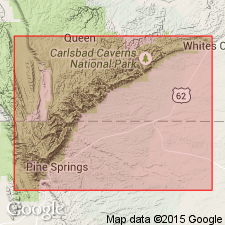
Tansill formation described in Carlsbad Caverns East quadrangle, New Mexico, where it is uppermost unit of Carlsbad group. Top has been removed by erosion in this quadrangle and at type locality. In subsurface, underlies Salado formation. [Age is Late Permian (Guadalupe).]
Source: US geologic names lexicon (USGS Bull. 1200, p. 3821-3822).
- Usage in publication:
-
- Tansill formation
- Modifications:
-
- Areal extent
- AAPG geologic province:
-
- Permian basin
Summary:
Pg. 375. Tansill formation. In Kent quadrangle [Culberson, Reeves, and Jeff Davis Counties, western Texas], underlies Yearwood formation (new). [Age is Late Permian (Guadalupe).]
Source: US geologic names lexicon (USGS Bull. 1200, p. 3821-3822).
- Usage in publication:
-
- Tansill Formation
- Modifications:
-
- Revised
- Reference
- Dominant lithology:
-
- Anhydrite
- AAPG geologic province:
-
- Permian basin
Summary:
Designated the upper formation of five formations of the newly named Artesia Group in Eddy Co, NM in Permian basin. Name Artesia applied to the shelf rock sequence. Overlies Yates Formation of the Artesia. Underlies Salado Formation. Reference well selected as the Humble Oil and Refining Co., Federal Bogle No. 1 in sec 30, T16S, R30E in Eddy Co where Tansill lies between 1,040 and 1,144 ft and where it is composed dominantly of anhydrite. Ocotillo Silt Member present. Cross sections. Correlation chart. Geologic map. Of late Guadalupian, Late Permian age.
Source: GNU records (USGS DDS-6; Denver GNULEX).

- Usage in publication:
-
- Tansill formation*
- Modifications:
-
- Overview
- AAPG geologic province:
-
- Permian basin
Summary:
Tansill Formation of Artesia Group adopted by the USGS. Term Carlsbad Group abandoned. Term Artesia Group (D.B. Tait and others, 1962, AAPG Bull., v. 46, no. 4) applied in New Mexico. Age is Late Permian (Guadalupe).
Source: US geologic names lexicon (USGS Bull. 1200, p. 3821-3822).
For more information, please contact Nancy Stamm, Geologic Names Committee Secretary.
Asterisk (*) indicates published by U.S. Geological Survey authors.
"No current usage" (†) implies that a name has been abandoned or has fallen into disuse. Former usage and, if known, replacement name given in parentheses ( ).
Slash (/) indicates name conflicts with nomenclatural guidelines (CSN, 1933; ACSN, 1961, 1970; NACSN, 1983, 2005, 2021). May be explained within brackets ([ ]).