

- Usage in publication:
-
- Storrs tongue*
- Modifications:
-
- Named
- Dominant lithology:
-
- Sandstone
- AAPG geologic province:
-
- Uinta basin
Summary:
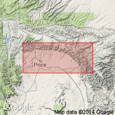
The name Storrs tongue is proposed for the middle tongue of Star Point Sandstone of Mesaverde group, from Storrs, Castlegate quadrangle, Carbon County, Utah, Uinta basin. Type locality not designated. Consists of thick-bedded sandstone at top, thin-bedded sandstone and sandy shale grading into shale at base. Forms a prominent cliff at Storrs. Thins east before it reaches Wellington quadrangle. Is friable at Kenilworth where it is 10 to 15 feet thick. Separated from underlying Panther tongue (new) of Star Point and the overlying Spring Canyon tongue (new) of Star Point by interfingering Mancos shale. Age is Late Cretaceous. Report includes geologic map, cross section.
Named from Storrs, in Uinta basin, Castlegate quadrangle, Carbon Co., UT.
Source: Modified from GNU records (USGS DDS-6; Menlo GNULEX).
For more information, please contact Nancy Stamm, Geologic Names Committee Secretary.
Asterisk (*) indicates published by U.S. Geological Survey authors.
"No current usage" (†) implies that a name has been abandoned or has fallen into disuse. Former usage and, if known, replacement name given in parentheses ( ).
Slash (/) indicates name conflicts with nomenclatural guidelines (CSN, 1933; ACSN, 1961, 1970; NACSN, 1983, 2005, 2021). May be explained within brackets ([ ]).