

- Usage in publication:
-
- Steve Creek Formation*
- Modifications:
-
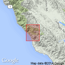
- Areal extent
- AAPG geologic province:
-
- California Coast Ranges province
Summary:
Unit geographically extended into report area. Described as marine pebbly sandstone, mudstone and conglomerate. Age is Late Cretaceous.
Source: GNU records (USGS DDS-6; Menlo GNULEX).
- Usage in publication:
-
- Steve Creek Formation*
- Modifications:
-
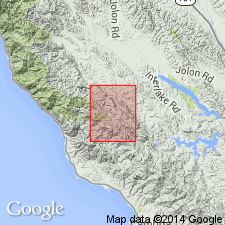
- Named
- Reference
- Dominant lithology:
-
- Sandstone
- Conglomerate
- AAPG geologic province:
-
- California Coast Ranges province
Summary:
Named for Steve Creek. Type locality is in small tributary of Steve Creek, 1.5 km west of Italian Flat in sec. 8 and 17, T24S R7E, Burnett Peak 7.5' quad, Monterey Co, CA. Reference locality exposing pebbly mudstone is in roadcut along Salmon Creek just south of mouth of Pozo Hondo Creek and adjacent to Nacimiento fault in sec. 22, T24S R7E. Reference section with sandstone is along north edge of sec. 9 and 10, T25S R8E [Bryson 7.5' quad, San Luis Obispo Co., CA]. Unit extends southeast across Burnett Peak across the southwest quarter of the Bryson 7.5' quad and the east into Pebblestone Shut-in 7.5' quad. Composed of marine sandstone, conglomerate, and mudstone. Informal member is mapped as discontinuous lenses of conglomerate with interbedded sandstone. Is 300 m thick at type and as much as 665 m in central part of the Burnett Peak 7.5 quad. Underlies Italian Flat Formation (new). Overlies Nacimiento fault. Assigned Late Cretaceous age based on pollen of Santonian through Danian age. May be Campanian(?) and (or) Maastrichtian(?) age since oldest rocks overlying Salinian block are Campanian in age (Howell and Vedder, 1978).
Source: GNU records (USGS DDS-6; Menlo GNULEX).
For more information, please contact Nancy Stamm, Geologic Names Committee Secretary.
Asterisk (*) indicates published by U.S. Geological Survey authors.
"No current usage" (†) implies that a name has been abandoned or has fallen into disuse. Former usage and, if known, replacement name given in parentheses ( ).
Slash (/) indicates name conflicts with nomenclatural guidelines (CSN, 1933; ACSN, 1961, 1970; NACSN, 1983, 2005, 2021). May be explained within brackets ([ ]).