

- Usage in publication:
-
- Soap Creek bentonite bed*
- Modifications:
-
- First used
- Dominant lithology:
-
- Bentonite
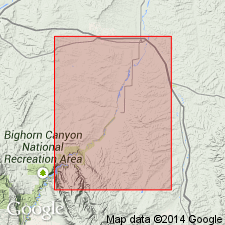
- AAPG geologic province:
-
- Central Montana uplift
Summary:
First published use as a name for an 8 ft thick olive-green bentonite at the top of Frontier formation of Colorado group. Intent to name, source of name, and designation of a type locality not stated. Overlies unnamed gray sandy shale of Frontier. Underlies dark gray shale of lower member of Cody shale. Identified on a columnar section. Late Cretaceous age.
Source: GNU records (USGS DDS-6; Denver GNULEX).
- Usage in publication:
-
- Soap Creek Bentonite Bed*
- Modifications:
-
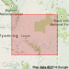
- Areal extent
- AAPG geologic province:
-
- Powder River basin
Summary:
Geographically extended from northwest WY to Kaycee in Johnson Co, WY on the west side of the Powder River basin where it is in the upper part of the Belle Fourche Member of the Frontier Formation. Overlies and underlies unnamed parts of the Belle Fourche. Of Late Cretaceous age.
Source: GNU records (USGS DDS-6; Denver GNULEX).
- Usage in publication:
-
- Soap Creek Bentonite Bed*
- Modifications:
-
- Biostratigraphic dating
- AAPG geologic province:
-
- Wind River basin
Summary:
Is recognized as a bed in the Belle Fourche Member of the Frontier Formation in northwestern Natrona Co, WY [Wind River basin]. Ammonite zonal index species ACANTHOCERAS AMPHIBOLUM Morrow is identified from a sandstone bed overlying the bentonite bed at two localities: 1) USGS Mesozoic locality D12959, NE1/4 sec 34, T39N, R83W; and 2) D13042, NE1/4 NE1/4 NE1/4 sec 34, T39N, R83W. A. AMPHIBOLUM zone is fifth of six (ascending) middle Cenomanian ammonite zones in the U.S. Western Interior. Age is middle Cenomanian (Late Cretaceous).
Source: GNU records (USGS DDS-6; Denver GNULEX).
For more information, please contact Nancy Stamm, Geologic Names Committee Secretary.
Asterisk (*) indicates published by U.S. Geological Survey authors.
"No current usage" (†) implies that a name has been abandoned or has fallen into disuse. Former usage and, if known, replacement name given in parentheses ( ).
Slash (/) indicates name conflicts with nomenclatural guidelines (CSN, 1933; ACSN, 1961, 1970; NACSN, 1983, 2005, 2021). May be explained within brackets ([ ]).