

- Usage in publication:
-
- Sitka Group*
- Modifications:
-
- Named
- Biostratigraphic dating
- Dominant lithology:
-
- Graywacke
- Argillite
- AAPG geologic province:
-
- Alaska Southeastern region
Summary:
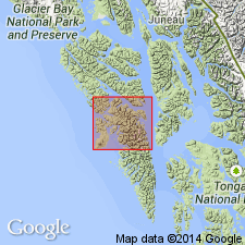
Named for exposures in its type area in vicinity of Sitka, western Baranof Island, southeastern AK. Forms discontinuous belt along southwest sides of Chichagof and Baranof Islands. Crops out from Old Sitka southeastward to Silver Bay, forms large parts of Krestof, Partofshikof, and Kruzof Islands, and makes up smaller islands near Sitka. Is thin- to medium-bedded interstratified graywacke and argillite and slaty argillite with less abundant massive graywacke, conglomerate and breccia. Is at least several 1000 ft thick. Overlies Kelp Bay Group (new). Unconformably underlies Edgecumbe Volcanics (new). Includes fossils of Early Cretaceous age (R.R. Coats, oral commun., 1961). Late Jurassic fossils were collected from rocks at Slocum Arm which are probably correlative with Sitka Group. Age is Late Jurassic(?) and Early Cretaceous.
Source: GNU records (USGS DDS-6; Menlo GNULEX).
- Usage in publication:
-
- Sitka Graywacke*
- Modifications:
-
- Revised
- Redescribed
- Age modified
- Biostratigraphic dating
- Dominant lithology:
-
- Graywacke
- Argillite
- Conglomerate
- AAPG geologic province:
-
- Alaska Southeastern region
Summary:
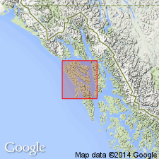
Sitka Group of Berg and Hinckley (1963) reduced in rank and redescribed as Sitka Graywacke because thick-bedded graywacke dominants. Less abundant rock types include thin-bedded graywacke, argillite, conglomerate, and breccia as well as minor chert, greenschist, slate, and limestone. Fossils (collected on Slocum Arm) including BUCHIA, indicate Late Jurassic and Early Cretaceous age (D.L. Jones, written commun., 1962).
Source: GNU records (USGS DDS-6; Menlo GNULEX).
- Usage in publication:
-
- Sitka Graywacke*
- Modifications:
-
- Areal extent
- Age modified
- AAPG geologic province:
-
- Alaska Southeastern region
Summary:
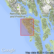
Recent mapping has shown that fossiliferous rocks of Slocum Arm are within Kelp Bay Group. Thus only fossils of Early Cretaceous age have been found in Sitka Graywacke on Kruzof Island. Unit intruded by Eocene granodiorite on Baranof Island. Assigned Cretaceous age.
Source: GNU records (USGS DDS-6; Menlo GNULEX).
For more information, please contact Nancy Stamm, Geologic Names Committee Secretary.
Asterisk (*) indicates published by U.S. Geological Survey authors.
"No current usage" (†) implies that a name has been abandoned or has fallen into disuse. Former usage and, if known, replacement name given in parentheses ( ).
Slash (/) indicates name conflicts with nomenclatural guidelines (CSN, 1933; ACSN, 1961, 1970; NACSN, 1983, 2005, 2021). May be explained within brackets ([ ]).