

- Usage in publication:
-
- Siemens Creek Formation*
- Modifications:
-
- Named
- Dominant lithology:
-
- Basalt
- Andesite
- AAPG geologic province:
-
- Wisconsin arch
Summary:
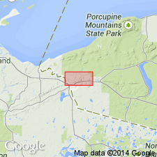
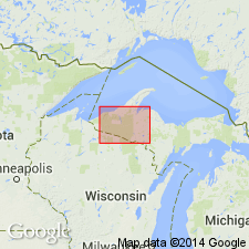
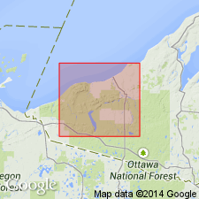
Named as a formation in Powder Mill Group (new). Named for Siemens Creek, west of Bessemer, Gogebic Co., northwestern MI (upper peninsula). Occurs in an area stretching from Ironwood, MI, westward to Mellen, WI, where it thins out. Underlies a prominent east-west body of knobby hills north of U.S. Hwy 2 in MI. Consists of olive-gray to dark-greenish-gray fine-grained basalt; also includes andesite. Mottled by patches of chlorite. Thickness is 4,400 ft near Ironwood, MI. Average thickness of flows is 9 ft but can be much thicker; basal flows measured at 115 and 175 ft. Flow tops are pahoehoe with very low relief and 5 percent vesicles. Conformably overlies Bessemer Quartzite (revised); unconformably(?) underlies Kallander Creek Formation (new). Report includes geologic map and correlation chart. Age is Precambrian Y (middle Keweenawan).
Source: GNU records (USGS DDS-6; Reston GNULEX).
- Usage in publication:
-
- Siemens Creek Formation*
- Modifications:
-
- Revised
- AAPG geologic province:
-
- Wisconsin arch
Summary:
Powder Mill Group and its lower Siemens Creek Formation and upper Kallander Creek Formation assigned to Keweenawan Supergroup.
Source: GNU records (USGS DDS-6; Reston GNULEX).
- Usage in publication:
-
- Siemens Creek Volcanics*
- Modifications:
-
- Revised
- AAPG geologic province:
-
- Wisconsin arch
Summary:
Revised the Siemens Creek to the Siemens Creek Volcanics to maintain consistency with similar Middle Proterozoic continental volcanic sequences in the Lake Superior region.
Source: GNU records (USGS DDS-6; Reston GNULEX).
For more information, please contact Nancy Stamm, Geologic Names Committee Secretary.
Asterisk (*) indicates published by U.S. Geological Survey authors.
"No current usage" (†) implies that a name has been abandoned or has fallen into disuse. Former usage and, if known, replacement name given in parentheses ( ).
Slash (/) indicates name conflicts with nomenclatural guidelines (CSN, 1933; ACSN, 1961, 1970; NACSN, 1983, 2005, 2021). May be explained within brackets ([ ]).