

- Usage in publication:
-
- Shurtliff Member
- Modifications:
-
- Original reference
- Dominant lithology:
-
- Sandstone
- Shale
- AAPG geologic province:
-
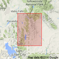
- Green River basin
Summary:
Pg. 14, 15 (fig. 2). Shurtliff Member of Hilliard Shale. Name proposed for 800 feet of alternating sandstones and shales occurring about 2,200 feet above base of the Hilliard. Overlain by about 2,500 feet of Hilliard Shale in type area. Pinches out south of T. 21 N., R. 116 W. Northward, in vicinity of T. 23 N., R. 116 W., the Shurtliff changes facies to continental sediments of Adaville Formation. Age is Late Cretaceous (Niobraran), based on fossils (pelecypods, cephalopods).
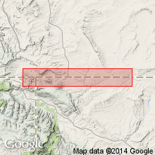
Typically exposed [along Hams Fork about 3 mi north-northwest of Frontier, in E/2 sec. 27, T. 22 N., R. 116 W., Kemmerer 15-min quadrangle, Lincoln Co.], southwestern WY. Named from Shurtliff Ranch, on Shurtliff Creek [now spelled Shurtleff] west of Round Mountain, in T. 17 N., R. 118 W., [Little Dee Creek 7.5-min quadrangle], Uinta Co., southwestern WY. [Additional locality information from Veatch, 1907, USGS Prof. Paper 56, pl. 26; USGS historical topographic map collection TopoView.]
[Misprint (US geologic names lexicon, USGS Bull. 1350, p. 692): typical exposures stated to be near Hilliard Ranch, in sec. 27, T. 22 N., R. 116 W. Town of Hilliard is several mi to south near Sulphur Creek Reservoir, in NW/4 sec. 2, T. 13 N., R. 119 W., Sulphur Creek Reservoir 7.5-min quadrangle.]
Source: US geologic names lexicon (USGS Bull. 1350, p. 692); supplemental information from GNU records (USGS DDS-6; Denver GNULEX).
- Usage in publication:
-
- Shurtliff Sandstone Member*
- Modifications:
-
- Revised
- AAPG geologic province:
-
- Green River basin
Summary:
Shurtliff Member (Smith, 1965) of Hilliard Shale changed to Shurtliff Sandstone Member of Hilliard Shale. Its type locality is along Hams Fork in sec 27, T22N, R116W in the Greater Green River basin. Is an 800 ft unit of sandstone ledges (lower 264 ft), dark-gray claystone and siltstone (middle 367 ft), and sandstone ledges (upper 73 ft). Overlies and intertongues with the lower member of the Hilliard; underlies and intertongues with the upper member of Hilliard. Is of Late Cretaceous age. Is a southward-extending tongue of Blind Bull Formation (new name).
Source: GNU records (USGS DDS-6; Denver GNULEX).
- Usage in publication:
-
- Shurtliff Member*
- Modifications:
-
- Overview
- Areal extent
- AAPG geologic province:
-
- Green River basin
Summary:
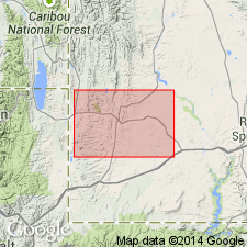
Is mapped as member within main body of Hilliard Shale in Lincoln Co, WY in western part of Greater Green River basin. Consists of ledge-forming gray to buff, fine-grained to gritty sandstone with abundant oyster shells in middle part of the Hilliard. Is about 300 m thick in northern part of the quadrangle; intertongues with main body of the Hilliard and pinches out southwest of Frontier, WY in west-central part of the quadrangle. Coniacian and Santonian (Late Cretaceous) age is indicated for the Hilliard on basis of palynomorphs.
Source: GNU records (USGS DDS-6; Denver GNULEX).
For more information, please contact Nancy Stamm, Geologic Names Committee Secretary.
Asterisk (*) indicates published by U.S. Geological Survey authors.
"No current usage" (†) implies that a name has been abandoned or has fallen into disuse. Former usage and, if known, replacement name given in parentheses ( ).
Slash (/) indicates name conflicts with nomenclatural guidelines (CSN, 1933; ACSN, 1961, 1970; NACSN, 1983, 2005, 2021). May be explained within brackets ([ ]).