

- Usage in publication:
-
- Sarten sandstone*
- Modifications:
-
- Named
- Dominant lithology:
-
- Sandstone
- AAPG geologic province:
-
- Basin-and-Range province
Summary:
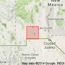
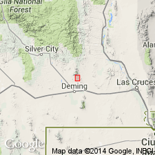
Named for Sarten Ridge, the prominent southern extension of Cooks Range, Luna Co, NM in Basin-and-Range province. Fluorite Ridge is also capped by this unit, and it is brought to the surface in the dome-shaped uplift of Goat Ridge. Constitutes the high cuesta north and east of Cooks Post Office; also appears in knobs and ridges to south, and south and east of the 55 ranch. At north edge of Sarten Ridge, in Cooks Post Office area, in Goat Ridge, and in a canyon on the southeast side of Sarten Ridge the Sarten sandstone is exposed, lying on Lobo formation (new). In Pony Hills, north of Fluorite Ridge, unit lies on or against granite--apparently due to faulting. At some localities the unit is overlain by Colorado shale without evidence of unconformity. Consists of light-gray, massive sandstone, most of it quartzitic or very hard. Some beds are slabby, and a few contain a little calcium carbonate. There is a conglomerate at base containing some angular and subangular fragments. The thickness in Sarten Ridge, Goat Ridge, and ridges east of Cooks Post Office is 300 ft; however, top removed by erosion in many areas and covered by later deposits. Faults and porphyry cut off the lower beds in various places. Most beds are barren of fossils, but some contain many; notably, a bed in middle of formation contains mollusks determined by Stanton to be forms of the Washita group of Comanche series (Early Cretaceous). Geologic map.
Source: GNU records (USGS DDS-6; Denver GNULEX).
- Usage in publication:
-
- Sarten Sandstone
- Modifications:
-
- Overview
- AAPG geologic province:
-
- Orogrande basin
- Basin-and-Range province
Summary:
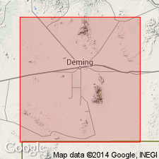
Lower Cretaceous formation in south-central NM, northeastern Dona Ana Co (Orogrande basin) and northern Luna Co (Basin-and-Range province). Southwest side San Andres Mountains southwest of Ash Canyon is 95-ft-thick clastic sequence unconformable between San Andres Formation (Lower Permian) and Dakota? Sandstone (Lower Cretaceous); consists interbedded yellowish-brown to purplish silty sandstone, gray sandy fossiliferous shale, brown fossiliferous limy sandstone, olive glauconitic sandstone, black carbonaceous shale; referred to Sarten in general sense as used by Darton (1928) and due to some lithic resemblance to type Sarten near Cooks Peak. In Cooks Peak area 300 ft thick; conformably overlain by Colorado Shale (Upper Cretaceous); consists light-gray, fine- to medium-grained quartz sandstone; quartz grains well sorted, subangular, cemented by silica, some beds with small to large amount calcite cement; bedding planes marked by hematite-rich laminae; bedding thin to massive and even; middle part fossiliferous. Author says Beartooth correlates directly with Sarten; Sarten, Beartooth, Dakota? of area from Silver City east to Sacramento Mountains may all be roughly correlative units with 1) lower part Early Cretaceous age and upper part Late Cretaceous age, or 2) time-transgressive unit grading from Early Cretaceous age at south into Late Cretaceous age to north. Isopach, facies map Lower Cretaceous strata in southwestern and south-central NM (fig 18).
Source: GNU records (USGS DDS-6; Denver GNULEX).
- Usage in publication:
-
- Sarten Sandstone*
- Modifications:
-
- Age modified
- AAPG geologic province:
-
- Basin-and-Range province
Summary:
Molluscan fossils collected by authors from top of Sarten suggest a Late Cretaceous, early Cenomanian age for upper part. Age of lower part remains Early Cretaceous, Albian based on marine mollusks collected by Darton in 1916. Is disconformably overlain by Colorado Formation. Luna Co, NM is in Basin-and-Range province.
Source: GNU records (USGS DDS-6; Denver GNULEX).
- Usage in publication:
-
- Sarten Sandstone*
- Modifications:
-
- Age modified
- AAPG geologic province:
-
- Basin-and-Range province
Summary:
Formerly, marine fossils collected by Darton from below the middle of the formation were determined as Early Cretaceous in age by T. W. Stanton (in Darton, 1916, p. 43). Recent collections of fossils from the Sarten Sandstone in the Cooke Range contain ammonites that permit a refined age assignment and correlation of the Sarten with age-equivalent units in west, north, and north-central Texas. Ammonite faunas were collected from three levels in the Sarten Sandstone. The oldest fauna came from a limy unit below the middle of the formation and is of middle late Albian age. A younger late Albian fauna was collected about 24 m above the limy beds. The upper meter of the Sarten has a fauna of early Cenomanian age.
Source: GNU records (USGS DDS-6; Denver GNULEX).
- Usage in publication:
-
- Sarten Sandstone*
- Modifications:
-
- Areal extent
- AAPG geologic province:
-
- Orogrande basin
Summary:
Exposed only in two lenticular fault blocks in the South Tularosa graben, Otero Co, NM in the southeastern part of the Orogrande basin. Top and base not exposed; next older unit is the Triassic Santa Rosa Sandstone; next younger unit is the Cretaceous Dakota Sandstone. Assigned an Early Cretaceous age.
Source: GNU records (USGS DDS-6; Denver GNULEX).
For more information, please contact Nancy Stamm, Geologic Names Committee Secretary.
Asterisk (*) indicates published by U.S. Geological Survey authors.
"No current usage" (†) implies that a name has been abandoned or has fallen into disuse. Former usage and, if known, replacement name given in parentheses ( ).
Slash (/) indicates name conflicts with nomenclatural guidelines (CSN, 1933; ACSN, 1961, 1970; NACSN, 1983, 2005, 2021). May be explained within brackets ([ ]).