

- Usage in publication:
-
- Salt Spring Slate*
- Modifications:
-
- Mapped 1:62.5k
- Dominant lithology:
-
- Slate
- AAPG geologic province:
-
- Sierra Nevada province
Summary:
Salt Spring Slate. Chiefly slate derived from siltstone; includes tuff, graywacke and petromict (polymict) conglomerate, and schistose metavolcanic rock. Age is Late Jurassic. Report includes cross section.
Source: US geologic names lexicon (USGS Bull. 1350, p. 661).
- Usage in publication:
-
- Salt Spring Slate
- Modifications:
-
- Named
- Dominant lithology:
-
- Slate
- Graywacke
- Tuff
- AAPG geologic province:
-
- Sierra Nevada province
Summary:
Pg. 29-30, pls. 1,8. Salt Spring Slate. Name applied to dominantly epiclastic rocks that overlie and intertongue with Gopher Ridge volcanics (new). Black sericite slate dominates formation, but graywacke and tuff are widespread and thin conglomerate layers occur in some places. Slate is exposed in continuous belt throughout length of area mapped. North of Stanislaus River, slate forms single formation that overlies Gopher Ridge volcanics (new). Underlies and intertongues with Copper Hill volcanics (new). The Salt Spring has been mapped as Mariposa by previous geologists.
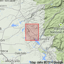
Type section: exposures in Cosumnes River near Michigan Bar Bridge, Amador Co. Named for Salt Spring Valley, which lies immediately east of Gopher Ridge, Calaveras Co. Poorly exposed in Salt Spring Valley.
Source: US geologic names lexicon (USGS Bull. 1350, p. 661).
For more information, please contact Nancy Stamm, Geologic Names Committee Secretary.
Asterisk (*) indicates published by U.S. Geological Survey authors.
"No current usage" (†) implies that a name has been abandoned or has fallen into disuse. Former usage and, if known, replacement name given in parentheses ( ).
Slash (/) indicates name conflicts with nomenclatural guidelines (CSN, 1933; ACSN, 1961, 1970; NACSN, 1983, 2005, 2021). May be explained within brackets ([ ]).