

- Usage in publication:
-
- Rocky Mountain Formation
- Modifications:
-
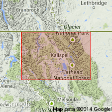
- Areal extent
- AAPG geologic province:
-
- Montana folded belt
Summary:
Mapped in area immediately south of CN border in north part of Whitefish Range, Flathead Co, MT in the Montana folded belt province. Consists of clean, well-sorted, gray, jointed, unfossiliferous quartzite and quartzitic sandstone. Weathers gray-yellow to pink. Cross-bedding. Ripple marks. Sandy and chert-bearing dolomite interbedded with quartzite in upper part of formation. Estimated to be 650 to 859 ft thick. Is younger than Etherington Formation (Mississippian) and older than Fernie Formation (Jurassic). Assigned to the Permian and Pennsylvanian.
Source: GNU records (USGS DDS-6; Denver GNULEX).
- Usage in publication:
-
- Rocky Mountain Formation*
- Modifications:
-
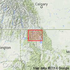
- Areal extent
- AAPG geologic province:
-
- Montana folded belt
Summary:
Mapped in a thrust plate in northeast Whitefish Range, Flathead Co, MT in the Montana folded belt province. Consists of gray, well-sorted, laminated, and cross-laminated quartzite that commonly has carbonate cement. Some ripple marks. Sandy dolomite beds with chert nodules in upper part. Maximum thickness of 600 ft. Overlies Mississippian rocks unconformably. Underlies Jurassic Fernie Formation unconformably. Assigned to the Pennsylvanian and Permian.
Source: GNU records (USGS DDS-6; Denver GNULEX).
For more information, please contact Nancy Stamm, Geologic Names Committee Secretary.
Asterisk (*) indicates published by U.S. Geological Survey authors.
"No current usage" (†) implies that a name has been abandoned or has fallen into disuse. Former usage and, if known, replacement name given in parentheses ( ).
Slash (/) indicates name conflicts with nomenclatural guidelines (CSN, 1933; ACSN, 1961, 1970; NACSN, 1983, 2005, 2021). May be explained within brackets ([ ]).