

- Usage in publication:
-
- Rio Loco formation
- Modifications:
-
- Named
Summary:
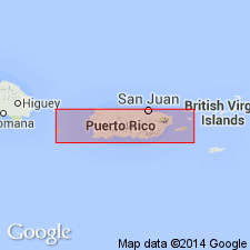
In Yauco area, a complex, more than 9000 meters thick, of volcanic flows with interbedded marine limestones, mudstones, tuffs, and sedimentary rocks derived from volcanic rocks, is divided into eight formations: Sabana Grande, El Rayo, Ensenada, Rio Yauco, Rio Loco, Rio Blanco, San German, and Jicara. The Rio Loco is considered to intertongue with Rio Yauco formation.
Source: GNU records (USGS DDS-6; Reston GNULEX).
- Usage in publication:
-
- Rio Loco†
- Modifications:
-
- Abandoned
Summary:
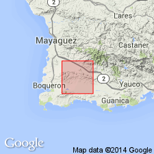
Rio Loco Formation is here abandoned at the suggestion of Krushensky because rocks named Rio Loco by Slodowski (1958) have been found to be intrusive rather than andesite lavas with minor volcaniclastic rocks.. Two-pyroxene basalt porphyry in the San German quadrangle that intrudes the Yauco and Sabana Grande was previously described as the Rio Loco.
Source: GNU records (USGS DDS-6; Reston GNULEX).
For more information, please contact Nancy Stamm, Geologic Names Committee Secretary.
Asterisk (*) indicates published by U.S. Geological Survey authors.
"No current usage" (†) implies that a name has been abandoned or has fallen into disuse. Former usage and, if known, replacement name given in parentheses ( ).
Slash (/) indicates name conflicts with nomenclatural guidelines (CSN, 1933; ACSN, 1961, 1970; NACSN, 1983, 2005, 2021). May be explained within brackets ([ ]).