

- Usage in publication:
-
- Revelo shale
- Modifications:
-
- Original reference
- Dominant lithology:
-
- Shale
- AAPG geologic province:
-
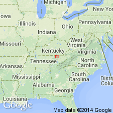
- Appalachian basin
Summary:
Pg. 504 (fig. 2), 507. Revelo shale. Made up largely of dark-gray shale that on outcrop is commonly brownish gray and includes interval between top of Crossville sandstone and base of Corbin [sandstone]. Thickness 40 feet at type locality. In places disappears where overlying Corbin cuts it out. In Tennessee represented by three formations (ascending): Burnt Mill shale, Coalfield sandstone, and Glenmary shale. [Age is Early Pennsylvanian.]
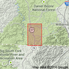
Named from exposures along U.S. Highway 27 at north edge of community of Revelo, [Whitley City 7.5-min quadrangle], McCreary Co., southeastern KY.
Source: US geologic names lexicon (USGS Bull. 1350, p. 628).
- Usage in publication:
-
- Revelo Shale
- Modifications:
-
- Not used
- AAPG geologic province:
-
- Appalachian basin
Summary:
Rocks in vicinity of Revelo, McCreary County, southeastern Kentucky, are included in Breathitt Formation and Corbin(?) Sandstone Member of Lee Formation.
Source: Publication.
For more information, please contact Nancy Stamm, Geologic Names Committee Secretary.
Asterisk (*) indicates published by U.S. Geological Survey authors.
"No current usage" (†) implies that a name has been abandoned or has fallen into disuse. Former usage and, if known, replacement name given in parentheses ( ).
Slash (/) indicates name conflicts with nomenclatural guidelines (CSN, 1933; ACSN, 1961, 1970; NACSN, 1983, 2005, 2021). May be explained within brackets ([ ]).