

- Usage in publication:
-
- Red Rim Member*
- Modifications:
-
- Original reference
- Dominant lithology:
-
- Sandstone
- AAPG geologic province:
-
- Green River basin
Summary:
Pg. 2-3, sheet 1 (figs. 1-3, geol. map), sheet 2. Red Rim Member, upper member of Lance Formation. Recognized in Washakie, Sand Wash, and Great Divide basins, Carbon County, southernmost Wyoming, and Moffat County, northwesternmost Colorado. Consists of series of thick sandstones separated by relatively thin layers of silty shale, carbonaceous shale, and mudstone. Thickness about 685 feet at type section. Overlies unnamed lower member of Lance Formation; contact placed at base of first major thick sandstone. Unconformably underlies China Butte Member (new) of Fort Union Formation; conglomerate at base of China Butte marks regional unconformity separating Tertiary from Cretaceous age rocks. Age is Late Cretaceous (late, but not latest Maastrichtian), based on fossils (palynomorphs). Report includes geologic map, measured sections, correlation chart, cross sections.
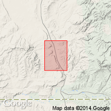
Type section: in area referred to locally as the "Cedars," located astride the Dad arch near WY State Highway 789; both upper and lower contacts of member well-exposed. Base of section 2,500 ft from east line and 700 ft from south line; top 1,200 ft from west line and 1,000 ft from south line, in sec. 3, T. 16 N., R. 92 W., Doty Mountain 7.5-min quadrangle, Carbon Co., southern WY. Named from Red Rim, a prominent ridge extending southwest from U.S. Highway I-80, in sec. 13, T. 21 N., R. 89 W., Rawlins Peak SW 7.5-min quadrangle, Carbon Co., WY, to Separation Creek in sec. 9, T. 19 N., R. 90 W., Riner 7.5-min quadrangle, Carbon Co., WY.
Source: Publication.
For more information, please contact Nancy Stamm, Geologic Names Committee Secretary.
Asterisk (*) indicates published by U.S. Geological Survey authors.
"No current usage" (†) implies that a name has been abandoned or has fallen into disuse. Former usage and, if known, replacement name given in parentheses ( ).
Slash (/) indicates name conflicts with nomenclatural guidelines (CSN, 1933; ACSN, 1961, 1970; NACSN, 1983, 2005, 2021). May be explained within brackets ([ ]).