

- Usage in publication:
-
- Purslane sandstone*
- Modifications:
-
- Named
- Dominant lithology:
-
- Sandstone
- Conglomerate
- AAPG geologic province:
-
- Appalachian basin
Summary:
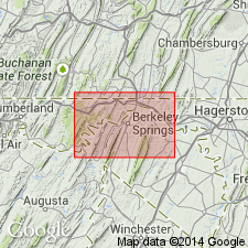
Massive hard coarse white sandstone which forms Purslane Mountain in Morgan Co., WV, here named Purslane sandstone and assigned to Pocono group. Contains milky-white quartz conglomerate alternating with softer cross-bedded sandstone with a little shale and thin coal seams. Thickness ranges from 180 to 310 ft. Also present in western MD. Underlies Hedges shale; overlies Rockwell formation, both of Pocono group. Age is Mississippian.
Source: GNU records (USGS DDS-6; Reston GNULEX).
- Usage in publication:
-
- Purslane sandstone member
- Modifications:
-
- Revised
- AAPG geologic province:
-
- Appalachian basin
Summary:
In Pawpaw-Hancock area, the Pocono is considered to have group rank and is divided into five formations; in western MD where the five units cannot be differentiated, the Pocono is treated as a formation and the Purslane as a member. In MD, uppermost beds have been eroded and thickest section is 144 ft. Consists of thick-bedded coarse white sandstone with interbedded conglomerate and with coal seams and red shales between the sandstones. In MD forms crest of Sideling Hill in Washington Co. and Town Hill in Allegany Co. Contains a few plant remains. Overlies Rockwell member. Age is Early Mississippian.
Source: GNU records (USGS DDS-6; Reston GNULEX).
- Usage in publication:
-
- Purslane Formation
- Modifications:
-
- Principal reference
- Revised
- AAPG geologic province:
-
- Appalachian basin
Summary:
Purslane Formation or Sandstone removed from Pocono Group. Pocono is abandoned in WV. Rockwell, Purslane, and Hedges contain distinctive enough lithologies to be recognized as separate formations. Principal reference sections for Purslane and Rockwell exposed in new roadcut through Sideling Hill along U.S. Rte 40, 10.4 km west of Hancock, MD. Unit equivalent to Burgoon Sandstone. Age is Osagean.
Source: GNU records (USGS DDS-6; Reston GNULEX).
- Usage in publication:
-
- Purslane Formation
- Modifications:
-
- Revised
- AAPG geologic province:
-
- Appalachian basin
Summary:
Author proposes that Rockwell and Purslane Formations be used instead of Pocono in MD. Pocono of previous usage in study area is abandoned. 87-ft-thick sandstone sequence assigned to Patton Shale Member of Rockwell Formation by Bjerstedt (1986), here referred to Purslane Formation. Patton Shale Member not used in study area. Contact of the Rockwell with the Purslane is placed at the base of the lowest thick sandstone (>30 ft). This increases the thickness of the Purslane in the vicinity of Sideling Hill from approximately 130 ft as defined by Stose and Swartz (1912), to well over 300 ft. Consists of 3 main sandstone units, all greater than 50 ft thick with intervening sequences of red claystone and black to dark-gray carbonaceous shale and siltstone. Underlies Late Mississippian Greenbrier Formation. Laterally equivalent to uppermost Rockwell and Burgoon of central PA and upper Price of south-central WV. Age of Purslane is Osagean.
Source: GNU records (USGS DDS-6; Reston GNULEX).

- Usage in publication:
-
- Purslane Sandstone
- Modifications:
-
- Overview
- AAPG geologic province:
-
- Appalachian basin
Summary:
The Meadow Branch synclinorium, Berkley Co., WV, is composed of five formations: Rockwell, Purslane, Hedges, Myers, and Pinkerton, for many years assigned to the Pocono Group. The three basal units are retained as Early Mississippian (Kinderhookian and Osagean), while the Myers and Pinkerton are now considered Late Mississippian (Meramecian). Only the Purslane is correlative with the original Pocono Formation of northeastern PA. Unit is a 150-m-thick sequence of medium to coarse sandstone with minor conglomerate beds. Contains several coal prospects near the top. Has been correlated with the Burgoon Sandstone of PA by Berg and Edmunds (1979).
Source: GNU records (USGS DDS-6; Reston GNULEX).
For more information, please contact Nancy Stamm, Geologic Names Committee Secretary.
Asterisk (*) indicates published by U.S. Geological Survey authors.
"No current usage" (†) implies that a name has been abandoned or has fallen into disuse. Former usage and, if known, replacement name given in parentheses ( ).
Slash (/) indicates name conflicts with nomenclatural guidelines (CSN, 1933; ACSN, 1961, 1970; NACSN, 1983, 2005, 2021). May be explained within brackets ([ ]).