

- Usage in publication:
-
- Priest Rapids Basalt Member
- Modifications:
-
- Original reference
- Dominant lithology:
-
- Basalt
- Diatomite
- AAPG geologic province:
-
- Eastern Columbia basin
Summary:
Pg. 5, 8 (fig. 2), 23-25, 35, 39. Priest Rapids Basalt Member of Yakima Basalt. Four flows that overlie Roza Basalt Member (new) at Priest Rapids Dam are referred to collectively as Priest Rapids Basalt Member; are chiefly medium- to coarse-grained, weather red brown, contain many diktytaxitic openings, phenocrysts are rare. Thicknesses based on drillholes at damsite are (ascending): flow no. 1, 30 +/-5 feet; no. 2, 40 +/-5 feet; no. 3, 60 +/-5 feet; and no. 4, 90 +/-10 feet. Flow no. 4 is directly overlain by Ellensburg Formation or by basalt flows interbedded in Ellensburg. Overlies Roza Basalt Member (new) of Yakima. Also includes Quincy diatomite (new). Laval (1956, unpub. thesis) assigns to Priest Rapids Basalt Member a thick sequence of strata measured in many sections in an area of several thousand square miles in south-central Washington, south of Priest Rapids. His section near Mabton includes three "basal Priest Rapids flows," aggregating 216 feet; the Mabton sedimentary interbed, 75 feet; Umatillo flow, about 285 feet; and Sillusi flow, about 100 feet; total thickness 650 to 700 feet. His suggestion that these be considered parts of Priest Rapids Basalt is workable arrangement; any or all of them can be raised to member or formational rank as understanding of the stratigraphy develops. [Age is late Miocene.]
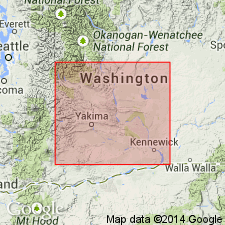
[Named from 4 flows at Priest Rapids Dam, exposed in south-dipping anticline on west side of reservoir (Priest Rapids Lake), Columbia River, Priest Rapids 7.5-min quadrangle, Yakima Co., south-central WA.]
Source: Publication; US geologic names lexicon (USGS Bull. 1350, p. 600); GNU records (USGS DDS-6; Menlo GNULEX).
- Usage in publication:
-
- Priest Rapids Member*
- Modifications:
-
- Areal extent
- Redefined
- Adopted
- AAPG geologic province:
-
- Columbia basin
- Idaho Mountains province
Summary:
Pg. C87-C90. Priest Rapids Member of Yakima Basalt of Columbia River Group. Name modified to Priest Rapids Member (adopted by the USGS). Geographically extended into Whitman and eastern Franklin Counties, southeastern Washington; sections in Yakawawa Canyon southwest of Pullman, [in SW/4 sec. 26 and NW/4 sec. 35, T. 13 N., R. 44 E., Pullman quadrangle (scale 1:125,000), Whitman Co.], and in Devils Canyon near Kahlotus, [in NW/4 sec. 9, T. 13 N., R. 34 E., Kahlotus 7.5-min quadrangle, Franklin Co.]. Is chiefly medium- to coarse-grained, nonporphyritic, diktytaxitic basalt, grayish black where fresh, red-brown to green where weathered, commonly with very large columns. Consists of one flow in Devils Canyon where it is about 50 feet thick and two(?) flows in Yakawawa Canyon where it is about 100 feet thick. Includes Quincy Diatomite Bed of Mackin (1961) or its equivalent in places. Overlies Roza Member of Yakima Basalt. Age is late Miocene or early Pliocene.
Source: Publication; US geologic names lexicon (USGS Bull. 1350, p. 600); Changes in stratigraphic nomenclature, 1965 (USGS Bull. 1244-A, p. A9); GNU records (USGS DDS-6; Menlo GNULEX).
- Usage in publication:
-
- Priest Rapids Member*
- Modifications:
-
- Revised
- Age modified
- AAPG geologic province:
-
- Eastern Columbia basin
Summary:
Pg. G3 (fig. 1), G7 (fig. 4), G9-G11. Priest Rapids Member of Yakima Basalt of Columbia River Group. Consists of four basalt flows with total thickness of 220 +/-25 feet. Basalt is grayish black were fresh, mottled greenish brown where weathered; coarse-grained and nonporphyritic; very large columns as much as 10 feet in diameter are common. Includes Quincy Diatomite Bed as thick as 35 feet at base in most of area. Overlies Roza Member. Underlies Saddle Mountains Member. Note on type area. Age is considered late Miocene based on stratigraphic relations of Yakima Basalt.
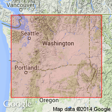
Type area: Rapids damsite on Columbia River in Yakima Co.
Source: Publication; US geologic names lexicon (USGS Bull. 1350, p. 600); GNU records (USGS DDS-6; Menlo GNULEX).
- Usage in publication:
-
- Priest Rapids Member*
- Modifications:
-
- Principal reference
- Revised
- Reference
- Age modified
- AAPG geologic province:
-
- Eastern Columbia basin
Summary:
Pg. G35-G37. Priest Rapids Member, upper member of Wanapum Basalt of Yakima basalt subgroup [informal] of Columbia River Basalt Group. Geographically extended from southeastern Washington into northwestern Idaho and northern Oregon. Includes all basalt flows above Roza Member of Wanapum and beneath Umatilla Member of Saddle Mountains Basalt (new) of the Yakima. †Quincy Diatomite Bed abandoned; rocks reallocated Squaw Creek Diatomite Bed of Ellensburg Formation. Has reversed magnetic polarity. Thickness about 65 m. Age is middle Miocene.
Type section is now mostly covered by water impounded behind the dam. Principal reference section (subsurface): cores from two holes PRE-1 and PRE-3 from below either end of Priests Rapids Dam; cores stored at Rockwell Hanford Operations, Richland, WA, and studied by personnel of Atlantic Richfield Hanford Company (1976, v. 2, p. A35-41).
REFERENCE LOCALITIES IN EASTERN PART OF PLATEAU:
(1) roadcut along Pasco-Kahlotus Highway at head of Devils Canyon, WA (described by Bingham and Walters, 1965);
(2) Whitlow quarry along Pullman-Moscow Highway, in SE/4 SW/4 sec. 4, T. 14 N., R. 45 E., Pullman quadrangle; the Priest Rapids in this general area was described in a study by Brown (1976);
(3) a foreset-bedded lava delta in roadcut 1.5 km southwest of Malden, WA (the basal flow in the Priest Rapids Member is pillowed over a wide area southwest of Malden) (Griggs, 1976, fig. 3);
(4) a columnar outcrop about 3 km south of Cavendish, ID, along highway to Ahsahka, in NE/4 SW/4 sec. 22, T. 37 N., R. 1 W., Ahsahka quadrangle (Bond, 1963);
(5) roadcuts along Highway 95A above 741 m elevation (2,430 ft), 8-13 km southeast of St. Maries. ID, in secs. 6 through 8, and 18, T. 45 N., R. 1 W., St. Maries, St. Joe, and Emida quadrangles (Griggs, 1976, p. 25; D.A. Swanson and T.L. Wright, unpub. data)
REFERENCE LOCALITIES IN WESTERN PART OF PLATEAU:
(1) southeast side of Sentinel Gap, 15 km north of type locality, where two flows in the member overlie Roza Member and underlie a thick conglomerate of Ellensburg Formation;
(2) south end of Union Gap, WA, along Thorpe Road;
(3) roadcuts along Highway I-80 just west of Arlington, OR;
(4) roadcuts along Highway 14 about 7 km east of Bingen, WA (Hammond and others, 1977).
[Yakima basalt subgroup considered informal and should not be capitalized. "Subgroup" not recognized as a formal stratigraphic rank term (CSN, 1933; ACSN, 1961, 1970; NACSN, 1983, 2005, 2021). Columbia River Basalt Group adopted by the ID, OR, and WA Geol. Surveys, and the USGS.]
[NOTE: The Department of the Interior's Secretarial Order 3404, issued on November 19, 2021, formally identifies the term “squaw” as derogatory. That Order will create a federal Derogatory Geographic Names Task Force, to find replacement names for geographic features in use by federal agencies. We’re awaiting guidance from the Task Force, and will then take the appropriate actions.]
Source: Publication; Changes in stratigraphic nomenclature, 1979 (USGS Bull. 1502-A, p. A59).
For more information, please contact Nancy Stamm, Geologic Names Committee Secretary.
Asterisk (*) indicates published by U.S. Geological Survey authors.
"No current usage" (†) implies that a name has been abandoned or has fallen into disuse. Former usage and, if known, replacement name given in parentheses ( ).
Slash (/) indicates name conflicts with nomenclatural guidelines (CSN, 1933; ACSN, 1961, 1970; NACSN, 1983, 2005, 2021). May be explained within brackets ([ ]).