

- Usage in publication:
-
- Prairie evaporite formation
- Modifications:
-
- Named
- Dominant lithology:
-
- Salt
- Anhydrite
- AAPG geologic province:
-
- Williston basin
Summary:
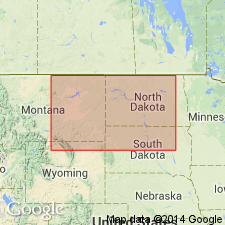
Named as the upper formation of the Elk Point group (rank raised). Occurs in subsurface of Elk Point basin of southern SA and adjacent AT and MB, CN, and south into ND and MT, Williston basin. Source of name not stated. Type section is the Imperial Davidson No. 1, sec 8, T27N, R1W, SA, CN in the Williston basin where it: lies between 4,350 and 5,000 ft; is composed of salt; overlies Winnipegosis formation of Elk Point group (rank raised); underlies Dawson Bay formation (new) of Manitoba group (new). Consists of salt and anhydrite. Ranges from less than 50 ft thick around the Elk Point basin margins to more than 600 ft thick near the center of the basin in east-central SA, CN. Cross sections. Correlation chart. Correlated with part of Maywood formation of northern MT. Extends south into northwest ND and east into southwest MB. Consists mainly of salt in central part of the basin. Anhydrite overlies the salt near the basin margins. Dolostone and red shale are present in some wells. Middle Devonian age. Was formerly mapped as part of the Winnipegosis.
Source: GNU records (USGS DDS-6; Denver GNULEX).
- Usage in publication:
-
- Prairie formation*
- Modifications:
-
- Revised
- Overview
- AAPG geologic province:
-
- Williston basin
Summary:
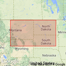
Name changed from Prairie evaporite formation to Prairie formation. Is the upper formation of the Elk Point group above the Winnipegosis formation of the Elk Point. Underlies Dawson Bay formation. Occurs in the subsurface in the deepest parts of the northern Williston basin of MT and ND. In center of basin, Prairie is divisible into a lower member of anhydrite and dolomite interbedded with shale and thin beds of halite, and an upper or salt member composed mostly of colorless, reddish-orange to grayish-red halite. The lower member changes facies to interbedded anhydritic dolomite, and dolomitic anhydritic shale and siltstone with inclusions of halite near the southern limit of the salt member in northern ND and MT. Farther south from the southern limit of the salt member, the lower member is an argillaceous limestone and dolomite. This gradation suggests evaporite was deposited in the center of the basin while carbonate rocks deposited around the margin. Also, the lower part of the salt member was probably deposited contemporaneously with the upper part of the lower member on the margins. Prairie has undergone solution in some areas. Of Middle Devonian age. Correlation chart. Cross section. Areal extent map of salt member.
Source: GNU records (USGS DDS-6; Denver GNULEX).
For more information, please contact Nancy Stamm, Geologic Names Committee Secretary.
Asterisk (*) indicates published by U.S. Geological Survey authors.
"No current usage" (†) implies that a name has been abandoned or has fallen into disuse. Former usage and, if known, replacement name given in parentheses ( ).
Slash (/) indicates name conflicts with nomenclatural guidelines (CSN, 1933; ACSN, 1961, 1970; NACSN, 1983, 2005, 2021). May be explained within brackets ([ ]).