

- Usage in publication:
-
- Poorman formation
- Modifications:
-
- Original reference
- Dominant lithology:
-
- Schist
- Slate
- AAPG geologic province:
-
- Midcontinent region
Summary:
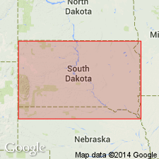
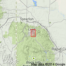
Pg. 793-799, 836-843, with maps. Poorman formation. Exposed mostly in the western, northwestern, and northern part of Lead district, Lawrence County, South Dakota. Most abundant rocks are carbonaceous banded mica (muscovite) schists and slates, of light-gray to dark-gray color, and fine-grained. A few beds of garnetiferous schist are interbedded. All rocks are schistose, tightly folded, and considerably cross-jointed. The formation is calcareous, graphitic, and pyritiferous. Thickness 2,500 feet. Basal formation in Lead district. Underlies De Smet formation, into which it grades. Age is Precambrian. Believed to be Keewatin age (Archean). Report includes geologic map.
Named from exposed section at junction of Poorman and Deadwood gulches along railroad track, Homestake Mine area, Lead district, Lawrence Co., southwestern SD.
Source: US geologic names lexicon (USGS Bull. 896, p. 1700); supplemental information from GNU records (USGS DDS-6; Denver GNULEX).

- Usage in publication:
-
- Poorman Formation*
- Modifications:
-
- Age modified
- AAPG geologic province:
-
- Midcontinent region
Summary:
Mapped with unit Xsc (Pl. 1) of Early Proterozoic age beneath the Poorman Formation. Is oldest stratified unit older than Homestake Formation in Lead area, SD, Midcontinent region. Geologic map.
Source: GNU records (USGS DDS-6; Denver GNULEX).
- Usage in publication:
-
- Poorman Formation*
- Modifications:
-
- Overview
- Dominant lithology:
-
- Amphibolite
- Schist
- Phyllite
- AAPG geologic province:
-
- Midcontinent region
Summary:
Divided into a lower unit of amphibolite (interpreted as tholeiitic metavolcanics) and an upper part of carbonate-rich rock, sericite-and-biotite-rich carbonate and quartz-bearing phyllite, and graphitic phyllite in the Homestake Mine area, Lawrence Co, SD in the Midcontinent region. Drilling indicates formation is generally 1,500 m thick. Lowest exposed unit called informally Yates unit. Yates extends for at least 10 km; it lies along strike from north to south at Lead. Upper part has: 1) slightly graphitic, fine-grained, gray, well-foliated, carbonate-rich schist with white chert layers and it is less than 1 to 30 m thick; and 2) three phyllite units that range from 0 to 230 m thick. One of the phyllite units has graphite poor and graphite rich layers. One of the phyllites is characterized by high biotite content. The third phyllite is called graphitic phyllite and is in layers 1 to 30+ m thick. Cross section. Geologic map. Stratigraphic chart. Deposited in a restricted basin. Early Proterozoic age. Underlies Homestake Formation.
Source: GNU records (USGS DDS-6; Denver GNULEX).
For more information, please contact Nancy Stamm, Geologic Names Committee Secretary.
Asterisk (*) indicates published by U.S. Geological Survey authors.
"No current usage" (†) implies that a name has been abandoned or has fallen into disuse. Former usage and, if known, replacement name given in parentheses ( ).
Slash (/) indicates name conflicts with nomenclatural guidelines (CSN, 1933; ACSN, 1961, 1970; NACSN, 1983, 2005, 2021). May be explained within brackets ([ ]).