

- Usage in publication:
-
- Pleasants member
- Modifications:
-
- First used
- Biostratigraphic dating
- Dominant lithology:
-
- Sandstone
- AAPG geologic province:
-
- Peninsular Ranges province
Summary:
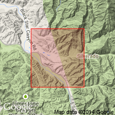
Pg. 380. Pleasants member of Williams formation (new). Briefly described in "Generalized section of formations in the Santa Ana Mountains, California." Is upper member (of 2) of Williams formation. Consists of light-colored shaly sandstones with many beds of limy fossiliferous sandstone intercalated. Thickness about 320 feet. Overlies Schulz member (new) of Williams formation. Unconformably underlies Eocene Martinez(?) formation. Age is Late Cretaceous based on molluscan fossils described in report.
Source: Publication; GNU records (USGS DDS-6; Menlo GNULEX); US geologic names lexicon (USGS Bull. 1200, p. 3064).
- Usage in publication:
-
- Pleasants sandstone member
- Modifications:
-
- Named
- Biostratigraphic dating
- Dominant lithology:
-
- Sandstone
- Limestone
- AAPG geologic province:
-
- Peninsular Ranges province
Summary:
Named as upper member (of 2) of Williams formation for Pleasants Ranch at mouth of Williams Canyon, Santa Ana Mountains, Orange Co, CA. Is discontinuous in its distribution; has been cut out by faulting and overlapping. Composed chiefly of very fine-grained, light-colored, thin-bedded, ferruginous and micaceous shaly sandstones interbedded with thick layers of cross-bedded calcareous or sandy limestones. Is about 320 ft thick. Overlies Schulz member of Williams formation; unconformably underlies Martinez formation. Age is Late Cretaceous based on molluscan fossils listed and described in report.
Source: GNU records (USGS DDS-6; Menlo GNULEX).
- Usage in publication:
-
- Pleasants sandstone member*
- Modifications:
-
- Adopted
- AAPG geologic province:
-
- Peninsular Ranges province
Summary:
Pleasants sandstone member of Williams formation shown on stratigraphic sections in northwestern Santa Ana Mountains as unconformably underlying Silverado formation (new). Some molluscan fossils listed. Age is Late Cretaceous.
Source: GNU records (USGS DDS-6; Menlo GNULEX).
- Usage in publication:
-
- Pleasants Sandstone Member
- Modifications:
-
- Overview
- AAPG geologic province:
-
- Peninsular Ranges province
Summary:
Paper provides paleoenvironmental synthesis of paleontological, ichnological and sedimentological data for Pleasants Sandstone Member of Williams Formation. Generalized stratigraphic column in Santa Ana Mountains shows Starr [Member] of Williams Formation interfingers with Pleasants Sandstone and Schulz Members. Report includes stratigraphic section of Pleasants Sandstone Member along Santiago Truck Trail, Modjeska Grade in Santa Ana Mountains, with thickness of 120 m.
Source: GNU records (USGS DDS-6; Menlo GNULEX).
For more information, please contact Nancy Stamm, Geologic Names Committee Secretary.
Asterisk (*) indicates published by U.S. Geological Survey authors.
"No current usage" (†) implies that a name has been abandoned or has fallen into disuse. Former usage and, if known, replacement name given in parentheses ( ).
Slash (/) indicates name conflicts with nomenclatural guidelines (CSN, 1933; ACSN, 1961, 1970; NACSN, 1983, 2005, 2021). May be explained within brackets ([ ]).