

- Usage in publication:
-
- Perryville formation
- Modifications:
-
- Named
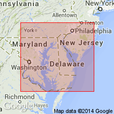
- Areal extent
- AAPG geologic province:
-
- Atlantic Coast basin
Summary:
Heterolithic fluvial sands and gravels at the mouth of the Susquehanna River and fringing the shoreline of Cecil and Harford Cos., MD, are herein informally called the Perryville formation. Unit is 1 to 6 m thick. Abundance of reworked, rounded ironstones in the Perryville strongly suggests the Bryn Mawr Formation as a major source. No dateable material has been found. However, the Perryville is younger than the Bryn Mawr and older than the Pensauken, Talbot, and Kent Island Formation, which are inset at lower elevations. The composition, stratigraphic position, and elevation of the Perryville resemble the Bridgeton Formation, the Yorktown Formation, the Park Hall Formation (McCartan, 1989) and the Bacons Castle Formation. Author favors a Pliocene age for the Perryville, although he states a Miocene to early Pleistocene age is possible.
Source: GNU records (USGS DDS-6; Reston GNULEX).
- Usage in publication:
-
- Perryville formation
- Modifications:
-
- First used
- Dominant lithology:
-
- Sand
- Gravel
- AAPG geologic province:
-
- Atlantic Coast basin
Summary:
Fan, terrace, and pediment deposits inset into the Oligocene and Miocene Bryn Mawr Formation are informally designated the Perryville formation by Pazzaglia (1993). This Pliocene deposit is largely derived from the Bryn Mawr and older Coastal Plain formations. Described as heterolithic, but quartz dominated. Contains labile clasts including saprolitized mafic and felsic igneous rocks from the Piedmont.
Source: GNU records (USGS DDS-6; Reston GNULEX).
For more information, please contact Nancy Stamm, Geologic Names Committee Secretary.
Asterisk (*) indicates published by U.S. Geological Survey authors.
"No current usage" (†) implies that a name has been abandoned or has fallen into disuse. Former usage and, if known, replacement name given in parentheses ( ).
Slash (/) indicates name conflicts with nomenclatural guidelines (CSN, 1933; ACSN, 1961, 1970; NACSN, 1983, 2005, 2021). May be explained within brackets ([ ]).