

- Usage in publication:
-
- Perrysburg formation*
- Modifications:
-
- Named
- Dominant lithology:
-
- Shale
- Siltstone
- Sandstone
- AAPG geologic province:
-
- Appalachian basin
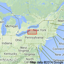
Summary:
Proposed Perrysburg formation for sequence between top of Hanover shale and base of Laona sandstone of Hall (1841). Clarke (1903) and Luther (1903) divided sequence into Dunkirk below and Portland above. Chadwick (1919) renamed upper part Gowanda beds as name Portland was preoccupied. Although Dunkirk and Gowanda can be traced from place to place in general way, they intergrade vertically to such an extent that they cannot be separately mapped; hence, new name is proposed. In western NY, rocks of Perrysburg comprise wedge of Upper Devonian deltaic sediments that thickens to south and east; in this wedge, lithology varies from interbedded black and gray shales containing siltstones in area bordering Lake Erie to massive siltstones and sandstones containing some gray shale in vicinity of PA-NY State line. Thickness at type locality is 416 feet. Comprises seven members (from northwest to southeast-direction of increasing grain size and clastic content): Dunkirk shale, South Wales, Canaseraga sandstone, Gowanda, Hume shale, Caneadea, and Canisteo shale members. Basal contact defined wherever exposed; top of formation recognized with certainty only as far east as Laona sandstone of Hall can be identified. From Franklin Gulf eastward unit overlies the Wiscoy sandstone. Age is Late Devonian.
Source: GNU records (USGS DDS-6; Reston GNULEX).
- Usage in publication:
-
- Perrysburg Formation*
- Modifications:
-
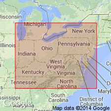
- Areal extent
- AAPG geologic province:
-
- Appalachian basin
Summary:
Perrysburg Formation (as its Dunkirk Shale Member) extended from southwestern NY and western PA into eastern OH and the subsurface of northern WV.
Source: GNU records (USGS DDS-6; Reston GNULEX).

- Usage in publication:
-
- Perrysburg Formation*
- Modifications:
-
- Overview
- AAPG geologic province:
-
- Appalachian basin
Summary:
In the type area, Perrysburg consists of the Dunkirk Shale Member (a basal black shale with calcareous nodules), the South Wales Member (a medial gray shale and siltstone sequence), and the Gowanda Shale Member (an upper gray shale and mudrock sequence with calcareous nodules and scattered beds of siltstone and black shale). Most of these rocks are fine to very fine grained. To the south and east, they grade into and interfinger with coarser grained quartzose rocks. The Dunkirk is the youngest extensive black shale in the NY section. In the subsurface, the Dunkirk extends from western NY to north-central WV and the net thickness of radioactive black shale exceeds 100 ft in northwestern PA. Near the PA-OH State line, the Dunkirk grades westward into the lower part of the Huron Member of the Ohio Shale. The vertical boundary between the Dunkirk Shale Member of the Perrysburg and the Huron Member of the Ohio is an arbitrary boundary set up for convenience and is not based on lithologic change.
Source: GNU records (USGS DDS-6; Reston GNULEX).
For more information, please contact Nancy Stamm, Geologic Names Committee Secretary.
Asterisk (*) indicates published by U.S. Geological Survey authors.
"No current usage" (†) implies that a name has been abandoned or has fallen into disuse. Former usage and, if known, replacement name given in parentheses ( ).
Slash (/) indicates name conflicts with nomenclatural guidelines (CSN, 1933; ACSN, 1961, 1970; NACSN, 1983, 2005, 2021). May be explained within brackets ([ ]).