

- Usage in publication:
-
- Perkinsville formation*
- Modifications:
-
- Named
- Dominant lithology:
-
- Gravel
- Sand
- Silt
- Basalt
- AAPG geologic province:
-
- Basin-and-Range province
Summary:
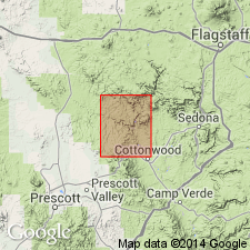
Name applied to a unit 0-500 ft thick of gravel and intercalated lava flows on the north side of the Verde River near Perkinsville, Yavapai Co, AZ in the Basin-and-Range province. Crops out in the northwest part of the Clarkville quad, Ts18 and 19N, Rs1 and 2E, and in the west-central part of the same quad on Black Mesa. Geologic map. No type locality designated. Thought to extend west and north of the quad boundaries. The gravel is coarse to fine, well bedded, rounded, and evenly sorted. Contains some sand, silt, and limestone present. Gravel consisting of basalt (60 percent), sandstone from the Coconino sandstone, limestone from the Kaibab limestone, rocks of the Supai formation, and chert derived from north of the rim sector of the plateau is found north of the Verde River. Gravel consisting of basalt (60 percent) and rocks from all the Paleozoic and Mesozoic formations is present south of the Verde River. Cobbles and boulders of Precambrian rocks were derived from the Pliocene? Hickey formation. White limestone interbedded with gravel near Black Mesa. Lava flows are black, gray, olivine basalt, except for one andesite flow; the flows are porphyritic. No fossils found. Correlated with Verde formation of Pliocene? to Pleistocene? age. Columnar section.
Source: GNU records (USGS DDS-6; Denver GNULEX).
- Usage in publication:
-
- Perkinsville Formation*
- Modifications:
-
- Overview
- Geochronologic dating
- AAPG geologic province:
-
- Basin-and-Range province
Summary:
Thought to have been deposited after uplift of Black Hills and development of the Verde River drainage. Lava flows of the Perkinsville north of the Verde River had sources near or north of the Mogollon Rim, and they flowed south in topographic depressions spilling, in part, over the rim. South of the Verde River, the relief is less and the lava flows slope gently toward the river. Thickness of formation thought to range from 300 to 500 ft. K-Ar ages of 4.5 +/-0.2 to 6.0 +/-0.3 obtained from basalt (whole rock) in the Perkinsville. Geologic map. Shown as a Pliocene unit in the Clarksdale and Paulden quads, north and west of Perkinsville, and as equivalent to the Verde Formation, southeast of Perkinsville in the Clarkdale and Mingus Mountain quad.
Source: GNU records (USGS DDS-6; Denver GNULEX).
For more information, please contact Nancy Stamm, Geologic Names Committee Secretary.
Asterisk (*) indicates published by U.S. Geological Survey authors.
"No current usage" (†) implies that a name has been abandoned or has fallen into disuse. Former usage and, if known, replacement name given in parentheses ( ).
Slash (/) indicates name conflicts with nomenclatural guidelines (CSN, 1933; ACSN, 1961, 1970; NACSN, 1983, 2005, 2021). May be explained within brackets ([ ]).