

- Usage in publication:
-
- Payette formation*
- Modifications:
-
- Named
- Dominant lithology:
-
- Sandstone
- Conglomerate
- Gravel
- AAPG geologic province:
-
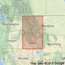
- Snake River basin
Summary:
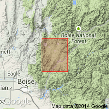
Name applied to some freshwater lake beds deposited in lower part of Snake River valley. Lies in front of the Boise Mountains and occupies ridge between Boise, Ada Co, and Payette, Payette Co. Extends north of Payette, along the Snake River and into OR between Owyhee River and Weiser, Washington Co, ID in Snake River basin. Forms bluffs 600 to 800 ft high. Smaller outcrops present in intermontane basins. Is 1,000 ft thick. Consists of granitic sand, hard sandstone, clayey semiconsolidated sandstone, conglomerate, and gravel. Some coal seams. Fossil plants (sequoia, oak, maple, etc.) listed. May be contemporaneous with John Day formation of OR, Ione formation of CA, Lamar flora of Yellowstone. Overlies granite. Payette Lake at its maximum extent stood at 4,200 ft el. Miocene age.
Source: GNU records (USGS DDS-6; Denver GNULEX).
- Usage in publication:
-
- Payette(?) formation
- Modifications:
-
- Not used
Summary:
Payette(?) formation of Mapel and Hail (USGS Bull. 1055-H, 1959), Goose Creek basin area, Cassia County, Idaho. Rocks previously mapped by Mapel and Hail as Payette(?) formation replaced with Beaverdam formation (new) in Idavada volcanics.
Source: Modified from GNU records (USGS DDS-6; Denver GNULEX).
- Usage in publication:
-
- Payette Formation*
- Modifications:
-
- Age modified
- AAPG geologic province:
-
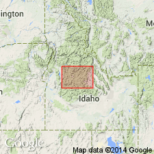
- Idaho Mountains province
Summary:
Age changed from Miocene and Pliocene? to Miocene on basis of presence of abundant impressions of upper middle to lower upper Miocene leaves identified by W. C. Rember. Mapped in southwest corner of map in Boise Co, ID in Idaho Mountains province.
Source: GNU records (USGS DDS-6; Denver GNULEX).
For more information, please contact Nancy Stamm, Geologic Names Committee Secretary.
Asterisk (*) indicates published by U.S. Geological Survey authors.
"No current usage" (†) implies that a name has been abandoned or has fallen into disuse. Former usage and, if known, replacement name given in parentheses ( ).
Slash (/) indicates name conflicts with nomenclatural guidelines (CSN, 1933; ACSN, 1961, 1970; NACSN, 1983, 2005, 2021). May be explained within brackets ([ ]).