

- Usage in publication:
-
- Panther tongue*
- Modifications:
-
- Named
- Dominant lithology:
-
- Limestone
- Sandstone
- Shale
- AAPG geologic province:
-
- Uinta basin
Summary:
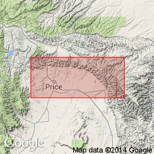
The name Panther tongue is proposed for the lowest tongue (does not occur at base) of Star Point sandstone of Mesaverde group, from exposures in Panther Canyon, Castlegate quadrangle, Carbon County, Utah, Uinta basin. Type locality not designated. Consists of impure limestone concretions, thin beds of sandstone, and sandy shale in east part of quadrangle. Thickens and becomes coarser and harder westward. Is a cliff-former 100-125 feet thick at west edge of quadrangle. Thins in Wellington quadrangle. Not present in Sunnyside quadrangle. Overlies Mancos shale. Is separated from the younger Storrs tongue (new) of Star Point by an interfingering wedge of Mancos. To west it merges with Storrs and together they are called lower part of Star Point. Age is Late Cretaceous. Report includes geologic map, cross section.
Named from exposures in Panther Canyon, in Uinta basin, Castlegate quadrangle, Carbon Co., UT.
Source: Modified from GNU records (USGS DDS-6; Menlo GNULEX).
- Usage in publication:
-
- Panther sandstone tongue
- Modifications:
-
- Revised
- AAPG geologic province:
-
- Uinta basin
Summary:
Star Point Sandstone revised in area of western Book Cliffs north and east of Spring Canyon, Carbon Co, UT in the Uinta basin to include the Panther sandstone tongue and the Storrs sandstone tongue. These two tongues are separated by a sandy shale tongue of the Mancos. The Panther is about 70 ft thick; it is a cliff-forming sandstone with lenses of limestone concretions; it is cross-bedded. The Storrs lies about 120 ft above the top of the Panther; it is composed of a sandy shale and shale that grades upward into thick-bedded medium-grained sandstone. Storrs is about 30 ft thick and it thins to east. The Spring Canyon member is removed from the Star Point in the western Book Cliffs and reassigned to the Blackhawk formation which overlies the Star Point. However, on the Wasatch Plateau, west of the Book Cliffs, Spring Canyon is retained in the Star Point because the Panther, Storrs, and Spring Canyon cannot be separated. Star Point is assigned a medial Montana age.
Source: GNU records (USGS DDS-6; Denver GNULEX).
- Usage in publication:
-
- Panther tongue
- Modifications:
-
- Overview
- AAPG geologic province:
-
- Uinta basin
Summary:
Is the basal 40 m thick, cliff-forming unit of Star Point Sandstone above and beneath shale of Mancos Shale. Can be subdivided in report area, Carbon Co, UT in the Uinta basin, into a basal thin-bedded, ripple marked siltstone and sandstone and an upper sandstone. Generally decreases in grain size eastward. Thins across the quad. Sandstone in the basal unit is gray to gray brown (gray-orange weathering). Siltstone in the basal unit is gray, heavily bioturbated. The upper sandstone is fine grained, 90 percent quartz, medium- to thick-bedded. Upper part has calcareous sandstone concretions which increase in number eastward. Fossil bivalve, abundant trace fossils. Of medial Montanan (Campanian) age. [No evidence presented for Campanian age.] Panther deposits probably represent a transition zone and lower shoreface environment offshore from a delta.
Source: GNU records (USGS DDS-6; Denver GNULEX).
For more information, please contact Nancy Stamm, Geologic Names Committee Secretary.
Asterisk (*) indicates published by U.S. Geological Survey authors.
"No current usage" (†) implies that a name has been abandoned or has fallen into disuse. Former usage and, if known, replacement name given in parentheses ( ).
Slash (/) indicates name conflicts with nomenclatural guidelines (CSN, 1933; ACSN, 1961, 1970; NACSN, 1983, 2005, 2021). May be explained within brackets ([ ]).