

- Usage in publication:
-
- Yamhill formation*
- Modifications:
-
- Original reference
- AAPG geologic province:
-
- Western Columbia basin
Summary:
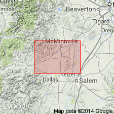
Yamhill formation. Name proposed for thick sequence of marine sedimentary rocks that overlie Siltetz River volcanic series. These sedimentary rocks have been known locally as Mill Creek beds. At Mill Creek, sedimentary rocks that compose lower 500 feet of formation are predominantly dark-gray shale and siltstone with occasional beds of lime-cemented sandstone. The siltstone and shale sequence along Mill Creek is overlain by sequence of massive sandstone beds. The sandstone is medium- to greenish-gray, thick-bedded, and fossiliferous. This sandstone is about 500 feet thick and grades upward into more argillaceous rock. Greenish-gray sand beds of the Yamhill are in turn overlain along Mill Creek by approximately 4,000 feet of finely micaceous siltstone and mudstone. Unconformably overlain by Nestucca formation. Yamhill and Burpee formations occupy same general stratigraphic position and are probably equivalent in age. Age of Yamhill is Eocene. (Yamhill formation adopted by the USGS.)
Type section: exposures along Mill Creek from a point 0.6 mi southeast of Mill Creek School. Formation best preserved within Yamhill Valley downwarp, which occupies broad area along South Yamhill River in Sheridan quadrangle, western OR.
Source: US geologic names lexicon (USGS Bull. 1200, p. 4315-4316).
- Usage in publication:
-
- Yamhill formation*
- Modifications:
-
- Overview
- AAPG geologic province:
-
- Western Columbia basin
Baldwin, E.M., 1959, Geology of Oregon: Ann Arbor, MI, Edwards Bros., Inc., __ p.
Summary:
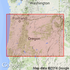
Pg. 13-14. Yamhill formation. Exposed along south slope of Yamhill Valley and southward through the Dallas area to Luckiamute River where it appears to interfinger with beds of Tyee formation. Near Dallas, limestone at base of formation is referred to as Dallas limestone member.
Source: US geologic names lexicon (USGS Bull. 1200, p. 4315-4316).
For more information, please contact Nancy Stamm, Geologic Names Committee Secretary.
Asterisk (*) indicates published by U.S. Geological Survey authors.
"No current usage" (†) implies that a name has been abandoned or has fallen into disuse. Former usage and, if known, replacement name given in parentheses ( ).
Slash (/) indicates name conflicts with nomenclatural guidelines (CSN, 1933; ACSN, 1961, 1970; NACSN, 1983, 2005, 2021). May be explained within brackets ([ ]).