

- Usage in publication:
-
- Newport sand member*
- Modifications:
-
- First used
- AAPG geologic province:
-
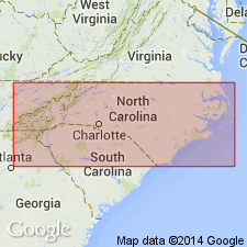
- Atlantic Coast basin
Summary:
Flanner Beach Formation of Du Bar and Solliday (1963) adopted for use by the USGS and stratigraphically restricted to exclude their Minnesott Ridge sand and other younger Pleistocene beds. Includes three informally named members: Beard Creek silty sand member, Arapahoe sand member and correlative Newport sand member. Flanner Beach unconformably overlies Yorktown Formation. Age is Pleistocene (pre-Sangamonian?).
Source: GNU records (USGS DDS-6; Reston GNULEX).
- Usage in publication:
-
- Newport Sand Member
- Modifications:
-
- Named
- Dominant lithology:
-
- Sand
- AAPG geologic province:
-
- Atlantic Coast basin
Summary:
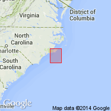
A barrier-sand lithosome associated with ridge-and-swale landforms in the Neuse River valley in Carteret Co., NC, is here named the Newport Sand Member of the Flanner Beach Formation, following the informal usage of Mixon and Pilkey (1976). It consists of pale-yellowish-gray, cross-bedded, fine to coarse, well-sorted quartz sand with quartz and chert pebbles and zones impregnated with black organic colloids (Mixon and Pilkey, 1976). Intertongues with the Beard Creek Member of the Flanner Beach to the northwest. Thickness ranges from 3 to 12 m. Age is middle Pleistocene.
Source: GNU records (USGS DDS-6; Reston GNULEX).
For more information, please contact Nancy Stamm, Geologic Names Committee Secretary.
Asterisk (*) indicates published by U.S. Geological Survey authors.
"No current usage" (†) implies that a name has been abandoned or has fallen into disuse. Former usage and, if known, replacement name given in parentheses ( ).
Slash (/) indicates name conflicts with nomenclatural guidelines (CSN, 1933; ACSN, 1961, 1970; NACSN, 1983, 2005, 2021). May be explained within brackets ([ ]).