

- Usage in publication:
-
- Nathrop Volcanics*
- Modifications:
-
- Named
- Dominant lithology:
-
- Tuff
- Breccia
- AAPG geologic province:
-
- Eagle basin
Summary:
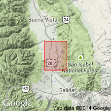
Named for community of Nathrop, Poncha Springs NE quad, Chaffee Co, CO. Type locality is in secs 11-13, T15S, R78W, in Eagle basin. Exposed in an area about 1/4 mi wide and 1 1/4 mi long in quad and north to Buena Vista quad. Composed of white to tan consolidated pumiceous tuff containing angular to subround unsorted fragments of tuff, glass, and some Precambrian rocks embedded in a matrix of pumice and shards, and a breccia within the tuff in which angular blocks of pumice as much as 4 ft across. Tuff is about 70 ft thick and breccia about 20 ft thick on east side of Ruby Mountain. Contains about 110 ft of perlite, gray to black isotropic glass that has shelly perlitic structure and rare spherulitic structure and abundant shiny pellets of black glass overlies tuff and breccia. A gray rhyolite flow about 300 ft thick that contains garnet, topaz, sanidine, quartz, tridymite, opal, calcite, magnetite, and hematite in vesicles and lithophysae forms upper part. Is about 600 ft thick. Rests on Precambrian gneissic quartz monzonite. Is of late Oligocene age; K-Ar age of 28.0 +/-0.8 to 29.3 +/-1.5 m.y. from obsidian pellets in perlite. Probably from source area to north near Sugarloaf Mountain or south near Bald Mountain. Is older than Dry Union Formation; cobbles of Nathrop occur with the Dry Union.
Source: GNU records (USGS DDS-6; Denver GNULEX).
For more information, please contact Nancy Stamm, Geologic Names Committee Secretary.
Asterisk (*) indicates published by U.S. Geological Survey authors.
"No current usage" (†) implies that a name has been abandoned or has fallen into disuse. Former usage and, if known, replacement name given in parentheses ( ).
Slash (/) indicates name conflicts with nomenclatural guidelines (CSN, 1933; ACSN, 1961, 1970; NACSN, 1983, 2005, 2021). May be explained within brackets ([ ]).